
Negele topographic map
Click on the map to display elevation.
Negele
Negele Borana or Neghelle, is a town and separate woreda in southern Ethiopia. Located in the Guji Zone of the Oromia Region on the road connecting Addis Ababa to Dolo Odo, it is the largest town in the Guji Zone, traditionally inhabited by the Borana Oromo. Specifically the town's inhabitants are mostly Soldiers and their families plus traders from different tribes living there since the HaileSillasie Regime. It has a latitude and longitude of 5°20′N 39°35′E / 5.333°N 39.583°E / 5.333; 39.583Coordinates: 5°20′N 39°35′E / 5.333°N 39.583°E / 5.333; 39.583 with an altitude of about 1,475 meters above sea level. Negele Borana principal importance is that a barrack revolt in this town is considered the first incident of the Ethiopian Revolution.[1] Moyale town is greatly affected by the regional clashes between Borana and the Somali community.
About this map
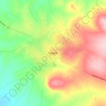
Name: Negele topographic map, elevation, terrain.
Location: Negele, Guji, Oromia Region, Ethiopia (5.29282 39.54066 5.37282 39.62066)
Average elevation: 4,902 ft
Minimum elevation: 4,541 ft
Maximum elevation: 5,308 ft
Other topographic maps
Click on a map to view its topography, its elevation and its terrain.
Moyale
Moyale has a hot semi-arid climate (Köppen BSh) moderated somewhat by altitude. Typically for East Africa, there are two rainy seasons: the “long rains” from March to May and the weaker, less reliable “short rains” in October and November.
Average elevation: 3,593 ft
Moyale
Moyale has a hot semi-arid climate (Köppen BSh) moderated somewhat by altitude. Typically for East Africa, there are two rainy seasons: the “long rains” from March to May and the weaker, less reliable “short rains” in October and November.
Average elevation: 3,593 ft
Asela
Asella (Oromo: Asallaa, Amharic: አሰላ) is a town in central Ethiopia. Located in the Arsi Zone of the Oromia Region 126 km (78 mi) south from Addis Ababa, this town has a latitude and longitude of 7°57′N 39°7′E / 7.950°N 39.117°E / 7.950; 39.117, with an elevation of 2,430 meters. Asella…
Average elevation: 7,969 ft
Lake Abaya
The only outflow of the lake is through the lower reaches of Kulfo River directly below an alluvial fan at an elevation of 1,190 m (at 6°00′39″N 37°35′07″E / 6.0109°N 37.5854°E / 6.0109; 37.5854). The riverbed acts as an spillway in the case of high lake levels and discharges the excess…
Average elevation: 4,826 ft
Harena Forest
The Harenna Forest is a montane tropical evergreen forest in Ethiopia's Bale Mountains. The forest covers the southern slope of the mountains, extending from 1450 to 3200 meters elevation. The Bale Mountains are in Ethiopia's Oromia Region, and form the southwestern portion of the Ethiopian Highlands.
Average elevation: 6,654 ft
Asela
Asella (Oromo: Asallaa, Amharic: አሰላ) is a town in central Ethiopia. Located in the Arsi Zone of the Oromia Region 156 km (97 mi) south from Addis Ababa, this town has a latitude and longitude of 7°57′N 39°7′E / 7.950°N 39.117°E / 7.950; 39.117, with an elevation of 2,430 meters. Asella…
Average elevation: 7,969 ft