
Asela topographic map
Click on the map to display elevation.
Asela
Asella (Oromo: Asallaa, Amharic: አሰላ) is a town in central Ethiopia. Located in the Arsi Zone of the Oromia Region 126 km (78 mi) south from Addis Ababa, this town has a latitude and longitude of 7°57′N 39°7′E / 7.950°N 39.117°E / 7.950; 39.117, with an elevation of 2,430 meters. Asella hosts an Asella Airport (IATA code ALK). Asalla was the capital of Arsi Province until that province was demoted to a Zone of Oromia with the adoption of the 1995 Constitution. It retains some administrative functions as the seat of the present Arsi Zone.
About this map
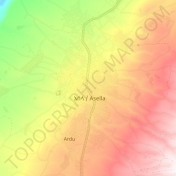
Name: Asela topographic map, elevation, terrain.
Location: Asela, Arsi, Oromia Region, Ethiopia (7.91776 39.11592 7.98971 39.15233)
Average elevation: 7,969 ft
Minimum elevation: 5,909 ft
Maximum elevation: 9,603 ft
Other topographic maps
Click on a map to view its topography, its elevation and its terrain.
Waliso
Waliso (Oromo: Walisoo) is a town in Southwest Shewa Zone of the Oromia Region in Ethiopia, 114 km southwest of Addis Ababa, it has a latitude and longitude of 8°32′N 37°58′E / 8.533°N 37.967°E / 8.533; 37.967 with an elevation of 2063 meters above sea level. Waliso is the administrative center of this Zone.
Average elevation: 6,706 ft
Entoto
Ethiopia > Oromia Region > Sululta
The Ethiopian Heritage Trust, a non-profit, non-governmental organization, is working actively to change part of the mountain to its old state, a natural park. Entoto Natural Park is the northeastern rim of Addis Abeba, on the southeastern slopes of Mt. Entoto, covering an area of 1,300 hectares. It is…
Average elevation: 9,905 ft
Negele
Negele Borana (Amharic: ነጌሌ ቦረና) is a town and separate woreda in southern Ethiopia. Located on the road connecting Addis Ababa to Moyale, it is the capital of the newly-established East Borana Zone of the Oromia Region. Negelle Borana is the largest city traditionally inhabited by the Borana…
Average elevation: 4,902 ft
Waliso
Waliso (Oromo: Walisoo) is a town in Southwest Shewa Zone of the Oromia Region in Ethiopia, 114 km southwest of Addis Ababa, it has a latitude and longitude of 8°32′N 37°58′E / 8.533°N 37.967°E / 8.533; 37.967 with an elevation of 2063 meters above sea level. Waliso is the administrative center of this Zone.
Average elevation: 6,706 ft
Chiro
Chiro (also called Asebe Teferi or Asba Littoria; Afaan Oromo: Ciroo) is a town and Aanaa in eastern Ethiopia. Located in the West Hararghe Zone in Oromia Regional State, Ethiopia Ahmar Mountains, it has a latitude and longitude of 9°05′N 40°52′E / 9.083°N 40.867°E / 9.083; 40.867 and an…
Average elevation: 6,135 ft
Asassa
Asasa is a town in southeastern Ethiopia. Located in the West Arsi Zone of the Oromia Region, this town has a latitude and longitude of 07°06′N 39°12′E / 7.100°N 39.200°E / 7.100; 39.200 with an elevation of 2367 meters above sea level. It is the administrative center of Gedeb Asasa woreda.
Average elevation: 7,815 ft
Adama
Ethiopia > Oromia Region > Adama
Adama (Oromo: Adaamaa or Hadaamaa, Amharic: አዳማ), formerly Nazreth (Amharic: ናዝሬት), is a city in central Oromia Region, Ethiopia. Adama forms a Special Zone of Oromia and is surrounded by East Shewa Zone. It is located at 8°32′N 39°16′E / 8.54°N 39.27°E / 8.54; 39.27 at an…
Average elevation: 5,489 ft
Sendafa
Sendafa (Oromo: Sandafaa; Amharic: ሰንዳፋ) is a town in central Ethiopia. It also serves as a separate district in the Oromia Region of Ethiopia, and its name is taken from the Oromo name for a kind of thick, jointed grass or reed which grows in swampy areas. Located in the Oromia Special Zone…
Average elevation: 8,510 ft
Bekoji
Bekoji (Oromo: Boqojjii, Amharic: በቆጂ) is a town in central Ethiopia. Located in the Arsi Zone of the Oromia Region, it has a latitude and longitude of 7°35′N 39°10′E / 7.583°N 39.167°E / 7.583; 39.167 with an elevation of 2810 m. It is the administrative centre of Limuna Bilbilo woreda.
Average elevation: 9,160 ft
Agaro
Agaro (also spelled Haggaro) (Oromo: Aggaaroo) is a town and separate woreda in south-western Ethiopia. Located in the Jimma Zone of the Oromia Region, it sits at an elevation of 1,560 meters above sea level.
Average elevation: 5,502 ft
Naqamte
Nekemte, also spelled as Neqemte (Oromo: Naqamtee, Amharic: ነቀምት), is a market city and separate woreda in western Ethiopia. Located in the East Welega Zone of the Oromia Region, Nekemte has a latitude and longitude of 9°5′N 36°33′E / 9.083°N 36.550°E / 9.083; 36.550 and an elevation of 2,088 meters.
Average elevation: 6,263 ft
Ambo
Ethiopia > Oromia Region > Ambo Zuria
Ambo (Oromo: Amboo) is a town in west-central Ethiopia. Located in the West Shewa Zone of Oromia Region, west of Addis Ababa. And it is the capital city of West Shewa zone. This town has a latitude and longitude of 8°59′N 37°51′E / 8.983°N 37.850°E / 8.983; 37.850 and an elevation of 2,101 meters.
Average elevation: 7,822 ft
Sagure
Sagure is a town in south-eastern Ethiopia. Located in the Arsi Zone of the Oromia, this town has a latitude and longitude of 07°45′N 39°09′E / 7.750°N 39.150°E / 7.750; 39.150 with an elevation of 2568 meters above sea level. It is the administrative center of Digeluna Tijo, woreda.
Average elevation: 8,271 ft
Negele
Negele Borana or Neghelle, is a town and separate woreda in southern Ethiopia. Located in the Guji Zone of the Oromia Region on the road connecting Addis Ababa to Dolo Odo, it is the largest town in the Guji Zone, traditionally inhabited by the Borana Oromo. Specifically the town's inhabitants are mostly…
Average elevation: 4,902 ft
Sendafa
Sendafa (Oromo: Sandafaa) is a town and separate woreda in Oromia Region, Ethiopia. Its name is taken from the Oromo name for a kind of thick, jointed grass or reed which grows in swampy areas. Located in the Oromia Special Zone Surrounding Finfinne of the Oromia Region, Sendafa has a latitude and longitude of…
Average elevation: 8,510 ft
Mieso
Mieso (Oromo: Mi'eesso) is a town in eastern Ethiopia. Located in the WEST OROMIA of the OROMIA Region, it has a latitude and longitude of 9°14′N 40°45′E / 9.233°N 40.750°E / 9.233; 40.750 with an elevation of 1394 meters above sea level.
Average elevation: 4,491 ft
Naqamte
Nekemte, also spelled as Neqemte (Oromo: Naqamtee, Amharic: ነቀምት), is a market city and separate woreda in western Ethiopia. Located in the East Welega Zone of the Oromia Region, Nekemte has a latitude and longitude of 9°5′N 36°33′E / 9.083°N 36.550°E / 9.083; 36.550 and an elevation of 2,088 meters.
Average elevation: 6,263 ft
Entoto
Ethiopia > Oromia Region > Sululta
The Ethiopian Heritage Trust, a non-profit, non-governmental organization, is working actively to change part of the mountain to its old state, a natural park. Entoto Natural Park is the northeastern rim of Addis Abeba, on the southeastern slopes of Mt. Entoto, covering an area of 1,300 hectares. It is…
Average elevation: 9,905 ft
Metu
Metu (Oromo: Mattuu) is a market town and separate woreda in south-western Ethiopia. Located in the Illubabor Zone of the Oromia along the Sor River, this town has a latitude and longitude of 8°18′N 35°35′E / 8.300°N 35.583°E / 8.300; 35.583 and an altitude of 1605 meters. Metu was the capital…
Average elevation: 5,518 ft
Waliso
Waliso (Oromo: Walisoo) is a town in Southwest Shewa Zone of the Oromia Region in Ethiopia, 114 km southwest of Addis Ababa, it has a latitude and longitude of 8°32′N 37°58′E / 8.533°N 37.967°E / 8.533; 37.967 with an elevation of 2063 meters above sea level. Waliso is the administrative center of this Zone.
Average elevation: 6,706 ft
Robe
Arsi Robe is a town in south-eastern Oromia. It is named after the nearby Robe River. It is the administrative centre of the Robe (Aanaa) in the Arsi Zone of the Oromia State, this town has a latitude and longitude of 09°36′N 39°08′E / 9.600°N 39.133°E / 9.600; 39.133 with an elevation of 2435…
Average elevation: 8,005 ft
Lake Abaya
The only outflow of the lake is through the lower reaches of Kulfo River directly below an alluvial fan at an elevation of 1,190 m (at 6°00′39″N 37°35′07″E / 6.0109°N 37.5854°E / 6.0109; 37.5854). The riverbed acts as an spillway in the case of high lake levels and discharges the excess…
Average elevation: 4,826 ft
Holeta Genet
Ethiopia > Oromia Region > Walmara
Holeta (Amharic: ሆለታ) (Oromo: Holataa) is a town in the special zone of Oromia Region, Ethiopia. It has a latitude and longitude of 9°3′N 38°30′E / 9.050°N 38.500°E / 9.050; 38.500 and an altitude of 2391 meters above sea level.
Average elevation: 7,844 ft
Sokoru
The altitude of this woreda ranges from 1160 to 2940 meters above sea level; the highest points include Ali Shashema, Ali Derar and Kumbi. Perennial rivers include the Gilgel Gibe a tributary of the Gibe, and the Kawar; seasonal streams include the Melka Luku. A survey of the land in this woreda shows that…
Average elevation: 5,994 ft
Sire
Sire (also transliterated "Sirie") is a town in south-western Oromia. Located in the Arsi Zone of the Oromia, Ethiopia. This town has a latitude and longitude of 08°17′N 39°27′E / 8.283°N 39.450°E / 8.283; 39.450 with an altitude of 1793 meters above sea level. It is administrative center of…
Average elevation: 6,670 ft
Robe
Arsi Robe is a town in south-eastern Oromia. It is named after the nearby Robe River. It is the administrative centre of the Robe (Aanaa) in the Arsi Zone of the Oromia State, this town has a latitude and longitude of 09°36′N 39°08′E / 9.600°N 39.133°E / 9.600; 39.133 with an elevation of 2435…
Average elevation: 8,005 ft
Naqamte
Nekemte, also spelled as Neqemte (Oromo: Naqamtee, Amharic: ነቀምት), is a market city and separate woreda in western Ethiopia. Located in the East Welega Zone of the Oromia Region, Nekemte has a latitude and longitude of 9°5′N 36°33′E / 9.083°N 36.550°E / 9.083; 36.550 and an elevation of 2,088 meters.
Average elevation: 6,263 ft
Entoto
Ethiopia > Oromia Region > Sululta
The Ethiopian Heritage Trust, a non-profit, non-governmental organization, is working actively to change part of the mountain to its old state, a natural park. Entoto Natural Park is the northeastern rim of Addis Abeba, on the southeastern slopes of Mt. Entoto, covering an area of 1,300 hectares. It is…
Average elevation: 9,905 ft
Agaro
Agaro (Oromo: Aggaaroo) is a town and separate woreda in south-western Ethiopia. Located in the Jimma Zone of the Oromia Region, it sits at an elevation of 1,560 meters above sea level.
Average elevation: 5,502 ft