Geolocate

Bodegraven topographic map

Click on the map to display elevation.

About this map

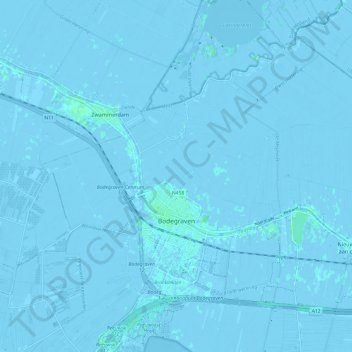
Name: Bodegraven topographic map, elevation, terrain.

Location: Bodegraven, Bodegraven-Reeuwijk, South Holland, Netherlands (52.06335 4.70473 52.12229 4.82539)

Average elevation: -3 ft

Minimum elevation: -23 ft

Maximum elevation: 13 ft

Other topographic maps

Click on a map to view its topography, its elevation and its terrain.

Botlek

Netherlands > South Holland

Average elevation: 10 ft

Meije

Netherlands > South Holland > Nieuwkoop

Average elevation: -7 ft

Langeraar

Netherlands > South Holland

Average elevation: -10 ft

Broekhuizen

Netherlands > South Holland > Gouda

Average elevation: -3 ft

Ankerpark

Netherlands > South Holland > Leiden

Average elevation: 10 ft

Middelsluis

Netherlands > South Holland > Numansdorp

Average elevation: 0 ft

Weerestein

Netherlands > South Holland > Hillegom

Average elevation: 0 ft

Weerestein

Netherlands > South Holland > Hillegom

Average elevation: 0 ft

Meijendel

Netherlands > South Holland > Wassenaar

Average elevation: 20 ft

Coepelduynen

Netherlands > South Holland > Katwijk

Average elevation: 13 ft

Het Park

Netherlands > South Holland > Rotterdam

Average elevation: 13 ft

Waalhaven

Netherlands > South Holland > Rotterdam

Average elevation: 10 ft

Gear up for your next adventure:

🛡️Insect Repellent - Protection against bugs during outdoor activities
📶Vehicle Signal Boosters - Improve reception in rural areas while driving to trailheads
❄️Traction Cleats - Prevent slips on icy trails during winter hikes
🧥Men's Rain Shells - Premium waterproof and breathable jackets for mountain weather
📻Weather Alert Radios - Stay informed of storm risks while off-the-grid

As an Amazon Associate, this site earns from qualifying purchases at no extra cost to you.