
Yateras topographic map
Interactive map
Click on the map to display elevation.
About this map
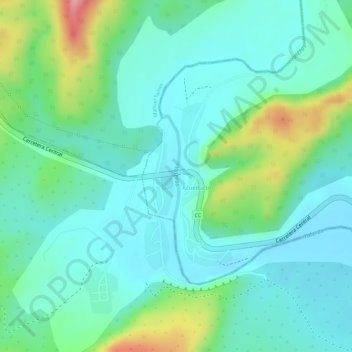
Name: Yateras topographic map, elevation, terrain.
Location: Yateras, San Antonio del Sur, Guantánamo, Cuba (20.01082 -75.03272 20.01759 -75.03226)
Average elevation: 190 ft
Minimum elevation: 72 ft
Maximum elevation: 505 ft
Other topographic maps
Click on a map to view its topography, its elevation and its terrain.
Guantanamo
Cuba > Guantánamo > Guantanamo
Guantanamo, Guantánamo, 95100, Cuba
Average elevation: 482 ft
Vega Larga
Cuba > Guantánamo > Baracoa
Vega Larga, Baracoa, Guantánamo, 97310, Cuba
Average elevation: 180 ft
Yateras
Cuba > Guantánamo > Yateras > Felicidad de Yateras
Yateras, Felicidad de Yateras, Yateras, Guantánamo, Cuba
Average elevation: 1,831 ft
Bano
Cuba > Guantánamo > Guantanamo
Bano, Guantanamo, Guantánamo, 95400, Cuba
Average elevation: 318 ft