
Make a donation
Gear up for your next adventure:
As an Amazon Associate, this site earns from qualifying purchases at no extra cost to you.
Chinchón topographic map
Click on the map to display elevation.
Make a donation
Gear up for your next adventure:
As an Amazon Associate, this site earns from qualifying purchases at no extra cost to you.
Chinchón
It has an irregular shape in plan with a simple and orderly structure in elevation. The buildings have three floors, with lintelled galleries and 234 wooden balconies called claros, supported by upright wooden pillars.
Make a donation
Gear up for your next adventure:
As an Amazon Associate, this site earns from qualifying purchases at no extra cost to you.
About this map
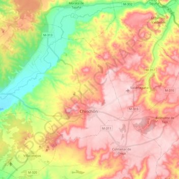
Name: Chinchón topographic map, elevation, terrain.
Location: Chinchón, Community of Madrid, 28370, Spain (40.09945 -3.58090 40.21854 -3.38544)
Average elevation: 2,185 ft
Minimum elevation: 1,677 ft
Maximum elevation: 2,589 ft
Make a donation
Gear up for your next adventure:
As an Amazon Associate, this site earns from qualifying purchases at no extra cost to you.
Other topographic maps
Click on a map to view its topography, its elevation and its terrain.
Make a donation
Gear up for your next adventure:
As an Amazon Associate, this site earns from qualifying purchases at no extra cost to you.
Alcorcón
Spain > Community of Madrid > Área metropolitana de Madrid y Corredor del Henares > Alcorcón
Average elevation: 2,119 ft
La Castellana y El Pilar
Spain > Community of Madrid > Sierra Oeste > Cadalso de los Vidrios
Average elevation: 2,585 ft