
Make a donation
Gear up for your next adventure:
As an Amazon Associate, this site earns from qualifying purchases at no extra cost to you.
Maui topographic map
Click on the map to display elevation.
Make a donation
Gear up for your next adventure:
As an Amazon Associate, this site earns from qualifying purchases at no extra cost to you.
Maui
Maui County's topography is characterized by a dramatic blend of volcanic mountains, rolling hills, and stunning coastal regions, creating a diverse landscape that contributes to its unique beauty. The island's centerpiece is Haleakalā, a massive shield volcano rising to an elevation of 10,023 feet, which is the highest point in the county and features a vast crater at its summit. The terrain varies significantly; while the coastal areas boast sandy beaches and lush coastal plains, the interior showcases rich agricultural lands and steep ridges. The West Maui Mountains, with peaks reaching around 5,788 feet, further enhance the island's ruggedness, while the eastern side transitions into tropical rainforests that receive substantial rainfall. This variety in elevation and climate creates distinct ecological zones, supporting a wide array of plant and animal life.
Make a donation
Gear up for your next adventure:
As an Amazon Associate, this site earns from qualifying purchases at no extra cost to you.
About this map
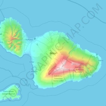
Name: Maui topographic map, elevation, terrain.
Location: Maui, Maui County, Hawaii, United States (20.57443 -156.69724 21.03156 -155.97909)
Average elevation: 761 ft
Minimum elevation: -13 ft
Maximum elevation: 9,987 ft
Maui County trails, hiking, mountain biking, running and outdoor activities
Make a donation
Gear up for your next adventure:
As an Amazon Associate, this site earns from qualifying purchases at no extra cost to you.
Other topographic maps
Click on a map to view its topography, its elevation and its terrain.
Kula
United States > Hawaii > Maui County
Kula is a district and census-designated place (CDP) of Maui, Hawaii, that stretches across the "up-country", the western-facing slopes of Haleakalā, from Makawao to Kanaio. Most of the residential areas lie between about 500 to 1,100 m (1,600 to 3,600 ft) in elevation. The district has traditionally been…
Average elevation: 2,428 ft
Make a donation
Gear up for your next adventure:
As an Amazon Associate, this site earns from qualifying purchases at no extra cost to you.
Make a donation
Gear up for your next adventure:
As an Amazon Associate, this site earns from qualifying purchases at no extra cost to you.
Haleakalā Observatories
United States > Hawaii > Maui County
The Haleakalā Observatory, also known as the Haleakalā High Altitude Observatory Site, is Hawaii's first astronomical research observatory. It is located on the island of Maui and is owned by the Institute for Astronomy of the University of Hawaiʻi, which operates some of the facilities on the site and…
Average elevation: 9,222 ft
Make a donation
Gear up for your next adventure:
As an Amazon Associate, this site earns from qualifying purchases at no extra cost to you.
Kula
United States > Hawaii > Maui County
Kula is a census-designated place (CDP) of Maui, Hawaii. It stretches across Upcountry Maui, the western-facing slopes of Haleakalā. Most residential areas lie between about 500 to 1,100 m (1,600 to 3,600 ft) in elevation. The district is distinct from the generally hotter and busier coastal areas. The…
Average elevation: 2,428 ft
Make a donation
Gear up for your next adventure:
As an Amazon Associate, this site earns from qualifying purchases at no extra cost to you.
Molokini Shoal Marine Life Conservation District
United States > Hawaii > Maui County
Average elevation: 0 ft
Make a donation
Gear up for your next adventure:
As an Amazon Associate, this site earns from qualifying purchases at no extra cost to you.
Make a donation
Gear up for your next adventure:
As an Amazon Associate, this site earns from qualifying purchases at no extra cost to you.