
Schüpfheim topographic map
Interactive map
Click on the map to display elevation.
About this map
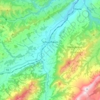
Name: Schüpfheim topographic map, elevation, terrain.
Location: Schüpfheim, Lucerne, 6170, Suisse (46.90957 7.94683 46.98045 8.07053)
Average elevation: 3,343 ft
Minimum elevation: 2,221 ft
Maximum elevation: 6,414 ft
Other topographic maps
Click on a map to view its topography, its elevation and its terrain.
Tellenmoos
Suisse > Lucerne > Escholzmatt-Marbach
Tellenmoos, Escholzmatt-Marbach, Lucerne, 6182, Suisse
Average elevation: 3,002 ft
Hochwäldli
Suisse > Lucerne > Schwarzenberg
Hochwäldli, Schwarzenberg, Lucerne, 6013, Suisse
Average elevation: 2,936 ft
Ebersecken
Suisse > Lucerne > Ebersecken
Ebersecken, Altishofen, Lucerne, 6246, Suisse
Average elevation: 2,096 ft
UNESCO Biosphère d'Entlebuch
UNESCO Biosphère d'Entlebuch, Flühli, Lucerne, 6173, Suisse
Average elevation: 3,757 ft