Geolocate
👉 Easily get elevation data in JSON, GeoTIFF and KML formats using Elevation API
Thank you for supporting this site ❤️
Make a donation

Valgrana topographic map

Click on the map to display elevation.

About this map

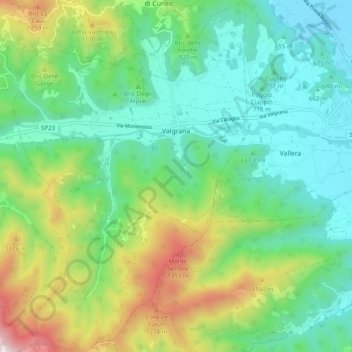
Name: Valgrana topographic map, elevation, terrain.

Location: Valgrana, Cuneo, Piedmont, Italy (44.36727 7.33463 44.43721 7.40030)

Average elevation: 2,818 ft

Minimum elevation: 1,814 ft

Maximum elevation: 5,249 ft

Other topographic maps

Click on a map to view its topography, its elevation and its terrain.

Bertolini

Italy > Piedmont > Cuneo > Crissolo

Average elevation: 5,531 ft

Montescotto

Italy > Piedmont > Cuneo > Barge

Average elevation: 2,110 ft

Monastero

Italy > Piedmont > Cuneo > Mondovì

Average elevation: 1,470 ft

Pievetta

Italy > Piedmont > Cuneo

Average elevation: 2,411 ft

Pianche

Italy > Piedmont > Cuneo

Average elevation: 4,908 ft

San Bernolfo

Italy > Piedmont > Cuneo > Vinadio

Average elevation: 6,680 ft

Gear up for your next adventure:

🔋Solar Power Banks - Keep your GPS and phone charged in remote wilderness areas
🖼️Topo Map Wall Art - Decorative topographic prints of famous peaks and regions
🛡️Bear Spray Outdoor - Protection in bear country hikes
👓Polarized Sunglasses - Outdoor sunglasses for glare reduction
🧭Compass with Lanyard - Easy‑carry compass for navigation

As an Amazon Associate, this site earns from qualifying purchases at no extra cost to you.