
Stapleford topographic map
Click on the map to display elevation.
About this map
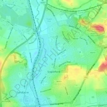
Name: Stapleford topographic map, elevation, terrain.
Average elevation: 177 ft
Minimum elevation: 108 ft
Maximum elevation: 335 ft
Other topographic maps
Click on a map to view its topography, its elevation and its terrain.
Manor House Pond
United Kingdom > England > Nottinghamshire > Broxtowe > Bramcote
Average elevation: 187 ft
Nottingham Canal Local Nature Reserve
United Kingdom > England > Nottinghamshire > Broxtowe
Average elevation: 217 ft
Attenborough Nature Reserve
United Kingdom > England > Nottinghamshire > Broxtowe > Beeston
Average elevation: 112 ft