
Make a donation
Gear up for your next adventure:
As an Amazon Associate, this site earns from qualifying purchases at no extra cost to you.
la Mola topographic map
Click on the map to display elevation.
Make a donation
Gear up for your next adventure:
As an Amazon Associate, this site earns from qualifying purchases at no extra cost to you.
la Mola
La Mola (cuyo nombre significa, literalmente, «la mesa») es la montaña más alta del parque natural de San Lorenzo del Munt y del Obac con 1104 metros de altitud (partiendo del nivel del mar) y es uno de los elementos característicos del paisaje en toda la comarca.
Make a donation
Gear up for your next adventure:
As an Amazon Associate, this site earns from qualifying purchases at no extra cost to you.
About this map
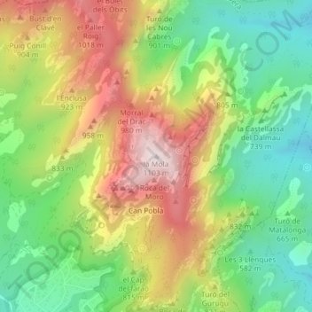
Name: la Mola topographic map, elevation, terrain.
Average elevation: 2,457 ft
Minimum elevation: 1,594 ft
Maximum elevation: 3,579 ft
Make a donation
Gear up for your next adventure:
As an Amazon Associate, this site earns from qualifying purchases at no extra cost to you.
Other topographic maps
Click on a map to view its topography, its elevation and its terrain.