
Tatamy topographic map
Click on the map to display elevation.
About this map
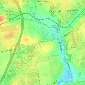
Name: Tatamy topographic map, elevation, terrain.
Average elevation: 374 ft
Minimum elevation: 295 ft
Maximum elevation: 453 ft
Northampton County trails, hiking, mountain biking, running and outdoor activities
Other topographic maps
Click on a map to view its topography, its elevation and its terrain.
Weiders Crossing
United States > Pennsylvania > Northampton County > Lehigh Township
Average elevation: 715 ft
Pennsville
United States > Pennsylvania > Northampton County > Lehigh Township
Average elevation: 627 ft
Stouts
United States > Pennsylvania > Northampton County > Williams Township > Stouts
Average elevation: 541 ft
Green Pond
United States > Pennsylvania > Northampton County > Bethlehem Township
Average elevation: 407 ft
Browntown
United States > Pennsylvania > Northampton County > Glendon > Browntown
Average elevation: 374 ft
Butztown
United States > Pennsylvania > Northampton County > Bethlehem Township
Average elevation: 361 ft
Raubsville
United States > Pennsylvania > Northampton County > Williams Township
Average elevation: 335 ft
Slateford
United States > Pennsylvania > Northampton County > Upper Mount Bethel Township
Average elevation: 630 ft
Kesslersville
United States > Pennsylvania > Northampton County > Plainfield Township
Average elevation: 581 ft