Geolocate

Chanchamayo topographic map

Click on the map to display elevation.

About this map

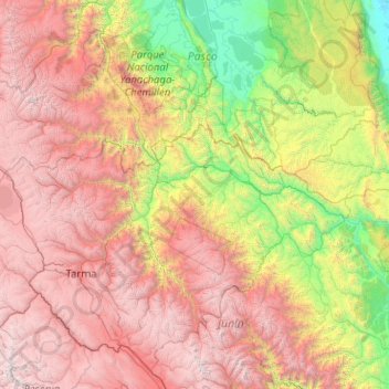
Name: Chanchamayo topographic map, elevation, terrain.

Location: Chanchamayo, Junín, Peru (-12.01473 -76.08922 -10.01473 -74.08922)

Average elevation: 7,694 ft

Minimum elevation: 554 ft

Maximum elevation: 18,484 ft

Other topographic maps

Click on a map to view its topography, its elevation and its terrain.

Huayucachi

Peru > Junín

Average elevation: 10,594 ft

Sausa

Peru > Junín

Average elevation: 11,122 ft

Huancayo

Peru > Junín

Average elevation: 12,523 ft

Santa Bárbara de Carhuacayán

Peru > Junín

Average elevation: 14,659 ft

Curicaca

Peru > Junín > Curicaca

Average elevation: 13,061 ft

Gear up for your next adventure:

🎒Gear Packing Cubes - Organize your backpack efficiently
🎒Trekking Poles - Sturdy poles for balance and stability on rough terrain
🔌Solar Panel Charger - Charge gear sustainably outdoors
🔋Rechargeable Batteries - Power up your outdoor devices
🛠️Backpacking Tool Kit - Essential toolkit for outdoor repairs

As an Amazon Associate, this site earns from qualifying purchases at no extra cost to you.