
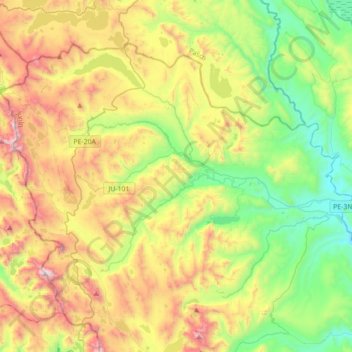
Santa Bárbara de Carhuacayán topographic map
Interactive map
Click on the map to display elevation.
About this map
Name: Santa Bárbara de Carhuacayán topographic map, elevation, terrain.
Location: Santa Bárbara de Carhuacayán, Yauli, Junín, Peru (-11.33259 -76.51923 -11.07042 -76.16719)
Average elevation: 14,659 ft
Minimum elevation: 12,933 ft
Maximum elevation: 17,454 ft
Other topographic maps
Click on a map to view its topography, its elevation and its terrain.
Andaychagua
Andaychagua, Huay-Huay, Yauli, Junín, Peru
Average elevation: 15,190 ft
General San Martin
Peru > Junín > Chanchamayo
General San Martin, Chanchamayo, Junín, Peru
Average elevation: 5,361 ft
Ciudad Satélite
Peru > Junín > Ciudad Satélite
Ciudad Satélite, Satipo, Junín, Peru
Average elevation: 2,520 ft
Marcapomacocha
Peru > Junín > Marcapomacocha
Marcapomacocha, Yauli, Junín, Peru
Average elevation: 15,007 ft