Geolocate

Chaffee topographic map

Click on the map to display elevation.

About this map

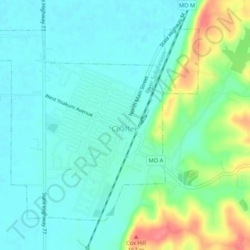
Name: Chaffee topographic map, elevation, terrain.

Location: Chaffee, Scott County, Missouri, 63240, United States (37.16890 -89.68172 37.19203 -89.64390)

Average elevation: 374 ft

Minimum elevation: 315 ft

Maximum elevation: 538 ft

Scott County trails, hiking, mountain biking, running and outdoor activities

Other topographic maps

Click on a map to view its topography, its elevation and its terrain.

Sikeston

United States > Missouri > Scott County > Sikeston > Sikeston

Average elevation: 315 ft

Gear up for your next adventure:

💧Water Purification System - Clean water on the trail with reliable purifiers
Backpacking Tents - Weight-optimized shelters for multi-day topographic surveys
🪶Multi‑Purpose Knife - Useful blade for camp and trail
🚗GPS Dash Cams - Record your scenic drives through mountain passes and canyons
🪓Survival Multi‑Tool - Versatile tool for camp and trail tasks

As an Amazon Associate, this site earns from qualifying purchases at no extra cost to you.