Geolocate

Conconully topographic map

Click on the map to display elevation.

About this map

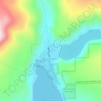
Name: Conconully topographic map, elevation, terrain.

Location: Conconully, Okanogan County, Washington, 98819, United States (48.55316 -119.75847 48.56591 -119.74576)

Average elevation: 2,730 ft

Minimum elevation: 2,267 ft

Maximum elevation: 3,809 ft

Okanogan County trails, hiking, mountain biking, running and outdoor activities

Other topographic maps

Click on a map to view its topography, its elevation and its terrain.

Point Defiance

United States > Washington > Okanogan County

Average elevation: 6,033 ft

Aeneas

United States > Washington > Okanogan County

Average elevation: 2,943 ft

Bonaparte Lake

United States > Washington > Okanogan County

Average elevation: 4,114 ft

Methow

United States > Washington > Okanogan County

Average elevation: 1,598 ft

Mazama

United States > Washington > Okanogan County

Average elevation: 2,713 ft

Chesaw

United States > Washington > Okanogan County

Average elevation: 3,432 ft

Copper Mountain

United States > Washington > Okanogan County

Average elevation: 1,184 ft

Molson

United States > Washington > Okanogan County

Average elevation: 3,957 ft

Goat Peak

United States > Washington > Okanogan County

Goat Peak is a 7,001-foot (2,134 m) peak in the North Cascades of Washington, United States. The summit offers broad views of the Methow River valley, as well as many of the other prominent cascade peaks including glaciated Silver Star Mountain. A working US Forest Service fire lookout is located on the…

Average elevation: 5,440 ft

Carlton

United States > Washington > Okanogan County

Average elevation: 1,939 ft

Mazama

United States > Washington > Okanogan County

Average elevation: 2,713 ft

Mazama

United States > Washington > Okanogan County

Average elevation: 2,713 ft

Aeneas

United States > Washington > Okanogan County

Average elevation: 2,943 ft

Twisp River

United States > Washington > Okanogan County > Twisp

Average elevation: 3,350 ft

Wauconda

United States > Washington > Okanogan County

Average elevation: 3,881 ft

Dutton Lakes

United States > Washington > Okanogan County

Average elevation: 6,867 ft

Rambo

United States > Washington > Okanogan County

Average elevation: 6,791 ft

Mount Barney

United States > Washington > Okanogan County

Average elevation: 6,683 ft

Gear up for your next adventure:

🪑Ultralight Camp Chairs - Portable seating for resting after a long day of mapping
🪶Fire Starter Kit - Reliable fire starter for survival and camping
🌡️Handheld Weather Meters - Measure wind, temp, and pressure for safe mountain travel
💧Water Filtration Bottles - Safely drink from streams and lakes while exploring
🔪Outdoor Multitools - Essential survival tools for gear repair and field use

As an Amazon Associate, this site earns from qualifying purchases at no extra cost to you.