
Mazama topographic map
Click on the map to display elevation.
About this map
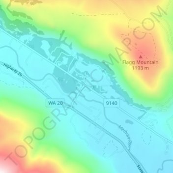
Name: Mazama topographic map, elevation, terrain.
Location: Mazama, Okanogan County, Washington, 98833, United States (48.57209 -120.42398 48.61209 -120.38398)
Average elevation: 2,713 ft
Minimum elevation: 2,031 ft
Maximum elevation: 4,649 ft
Okanogan County trails, hiking, mountain biking, running and outdoor activities
Other topographic maps
Click on a map to view its topography, its elevation and its terrain.
Tonasket
United States > Washington > Okanogan County
Tonasket is located at 48°42′20″N 119°26′19″W / 48.70556°N 119.43861°W / 48.70556; -119.43861 (48.705626, -119.438568). at an altitude of 1,311 ft (400 m).
Average elevation: 1,122 ft
Winthrop
United States > Washington > Okanogan County
Winthrop lies at the confluence of the Methow and Chewuch rivers in the Methow Valley. The town is in the eastern foothills of the Cascade Mountains at an elevation of 1,760 feet (540 m). The Okanogan–Wenatchee National Forest and state-managed Methow Wildlife Area surround the Methow Valley.
Average elevation: 1,860 ft
Omak
United States > Washington > Okanogan County
Elevations around the area range from 780 feet (240 m) above sea level at the mouth of the Okanogan River to 6,774 feet (2,065 m) above sea level at the Moses Mountain. The average elevation is 843 feet (257 m) above sea level according to the United States Geological Survey (USGS). The Moses Mountain, with a…
Average elevation: 1,194 ft
Grand Coulee Dam
United States > Washington > Okanogan County
After power shortages in the Northwest during the 1960s, it was determined the six remaining planned pumps be pump-generators. When energy demand is high, the pump-generators can generate electricity with water from the Banks Lake feeder canal adjacent to the dam at a higher elevation. By 1973, the…
Average elevation: 1,388 ft
Tonasket
United States > Washington > Okanogan County
Tonasket is located along the Okanogan River at an altitude of 1,311 ft (400 m).
Average elevation: 1,138 ft
Tonasket
United States > Washington > Okanogan County
Tonasket is located along the Okanogan River at an altitude of 1,311 ft (400 m).
Average elevation: 1,122 ft