Geolocate

Eagle Center topographic map

Click on the map to display elevation.

About this map

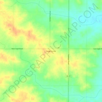
Name: Eagle Center topographic map, elevation, terrain.

Location: Eagle Center, Black Hawk County, Iowa, United States (42.32001 -92.37676 42.36001 -92.33676)

Average elevation: 928 ft

Minimum elevation: 866 ft

Maximum elevation: 988 ft

Black Hawk County trails, hiking, mountain biking, running and outdoor activities

Other topographic maps

Click on a map to view its topography, its elevation and its terrain.

Dunkerton

United States > Iowa > Black Hawk County

Average elevation: 971 ft

Elk Run Heights

United States > Iowa > Black Hawk County

Average elevation: 850 ft

Evansdale

United States > Iowa > Black Hawk County

Average elevation: 853 ft

Gilbertville

United States > Iowa > Black Hawk County

Average elevation: 863 ft

Hudson

United States > Iowa > Black Hawk County

Average elevation: 925 ft

La Porte City

United States > Iowa > Black Hawk County

Average elevation: 830 ft

Raymond

United States > Iowa > Black Hawk County

Average elevation: 902 ft

Gear up for your next adventure:

📡GPS Antenna Upgrade - Enhance GPS reception in remote terrain
🦺Reflective Outdoor Gear - Safety gear for low‑light conditions
🧢Sun Protection Hats - Wide-brimmed and UPF-rated hats for high-altitude sun safety
🧺Microfiber Travel Towels - Compact and fast-drying towels for trail use
🛡️Insect Repellent - Protection against bugs during outdoor activities

As an Amazon Associate, this site earns from qualifying purchases at no extra cost to you.