
Make a donation
Gear up for your next adventure:
As an Amazon Associate, this site earns from qualifying purchases at no extra cost to you.
Elk Run Heights topographic map
Click on the map to display elevation.
Make a donation
Gear up for your next adventure:
As an Amazon Associate, this site earns from qualifying purchases at no extra cost to you.
About this map
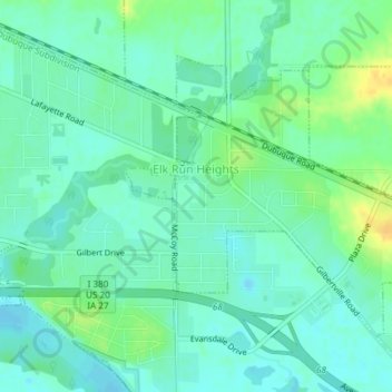
Name: Elk Run Heights topographic map, elevation, terrain.
Location: Elk Run Heights, Black Hawk County, Iowa, United States (42.45737 -92.26819 42.47699 -92.23106)
Average elevation: 850 ft
Minimum elevation: 823 ft
Maximum elevation: 906 ft
Black Hawk County trails, hiking, mountain biking, running and outdoor activities
Make a donation
Gear up for your next adventure:
As an Amazon Associate, this site earns from qualifying purchases at no extra cost to you.
Other topographic maps
Click on a map to view its topography, its elevation and its terrain.
Make a donation
Gear up for your next adventure:
As an Amazon Associate, this site earns from qualifying purchases at no extra cost to you.
Waterloo
United States > Iowa > Black Hawk County > Waterloo
The average elevation of Waterloo is 846 feet above sea level. The population density is 1101 people per square mile, considered low for an urban area.
Average elevation: 925 ft