Geolocate

Mora topographic map

Click on the map to display elevation.

About this map

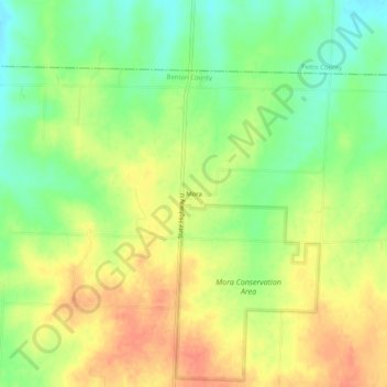
Name: Mora topographic map, elevation, terrain.

Location: Mora, Benton County, Missouri, United States (38.50363 -93.23576 38.54363 -93.19576)

Average elevation: 1,007 ft

Minimum elevation: 922 ft

Maximum elevation: 1,086 ft

Benton County trails, hiking, mountain biking, running and outdoor activities

Other topographic maps

Click on a map to view its topography, its elevation and its terrain.

Lincoln

United States > Missouri > Benton County

Average elevation: 935 ft

Ionia

United States > Missouri > Benton County

Average elevation: 961 ft

Gear up for your next adventure:

📱Solar Portable Charger - Solar power bank for charging devices off‑grid
🚑Emergency Bivvies - Heat-reflective sleeping bags for survival situations
💧Water Filtration Bottles - Safely drink from streams and lakes while exploring
🪶Multi‑Purpose Knife - Useful blade for camp and trail
🛠️Backpacking Tool Kit - Essential toolkit for outdoor repairs

As an Amazon Associate, this site earns from qualifying purchases at no extra cost to you.