Geolocate

Ionia topographic map

Click on the map to display elevation.

About this map

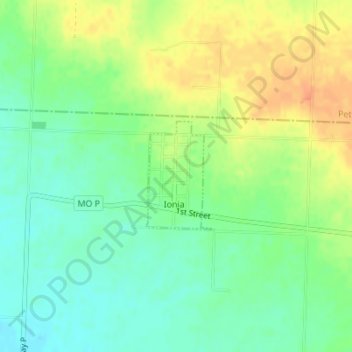
Name: Ionia topographic map, elevation, terrain.

Location: Ionia, Benton County, Missouri, United States (38.49981 -93.32641 38.50817 -93.31979)

Average elevation: 961 ft

Minimum elevation: 902 ft

Maximum elevation: 1,037 ft

Benton County trails, hiking, mountain biking, running and outdoor activities

Other topographic maps

Click on a map to view its topography, its elevation and its terrain.

Mora

United States > Missouri > Benton County

Average elevation: 1,007 ft

Crest

United States > Missouri > Benton County

Average elevation: 1,037 ft

White Branch

United States > Missouri > Benton County

Average elevation: 738 ft

Gear up for your next adventure:

🦺Reflective Outdoor Gear - Safety gear for low‑light conditions
🚪Portable Camp Chair - Foldable chair for comfort at camp
☀️Outdoor Sunscreen - High protection sunscreen for outdoor activities
🧢Outdoor Hiking Hat - Sun protection hat for outdoor explorers
🛰️Satellite Messengers - Emergency SOS and two-way messaging for off-grid adventures

As an Amazon Associate, this site earns from qualifying purchases at no extra cost to you.