Geolocate

Muscadine topographic map

Click on the map to display elevation.

About this map

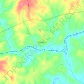
Name: Muscadine topographic map, elevation, terrain.

Location: Muscadine, Cleburne County, Alabama, 36269, United States (33.71455 -85.40607 33.75455 -85.36607)

Average elevation: 1,014 ft

Minimum elevation: 906 ft

Maximum elevation: 1,175 ft

Cleburne County trails, hiking, mountain biking, running and outdoor activities

Other topographic maps

Click on a map to view its topography, its elevation and its terrain.

Ranburne

United States > Alabama > Cleburne County

Average elevation: 994 ft

Edwardsville

United States > Alabama > Cleburne County

Average elevation: 965 ft

Heflin

United States > Alabama > Cleburne County

Average elevation: 991 ft

Fruithurst

United States > Alabama > Cleburne County

Average elevation: 1,083 ft

Gear up for your next adventure:

🪶Fire Starter Kit - Reliable fire starter for survival and camping
🛠️Backpacking Tool Kit - Essential toolkit for outdoor repairs
🧭Map Reading Tools - Tools and kits for map navigation
🪶Thermal Camp Blanket - Extra warmth for cold nights
🎒Gear Packing Cubes - Organize your backpack efficiently

As an Amazon Associate, this site earns from qualifying purchases at no extra cost to you.