
South Fork New River topographic map
Interactive map
Click on the map to display elevation.
About this map
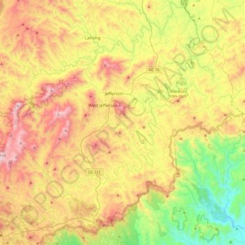
Name: South Fork New River topographic map, elevation, terrain.
Average elevation: 2,976 ft
Minimum elevation: 1,148 ft
Maximum elevation: 5,292 ft
Ashe County trails, hiking, mountain biking, running and outdoor activities
Other topographic maps
Click on a map to view its topography, its elevation and its terrain.
Lansing
United States > North Carolina > Ashe County
Lansing is a popular destination among retirees and tourists from Florida, as well as those from the lower elevations of the Carolinas and Georgia.
Average elevation: 3,009 ft