
Baldwin topographic map
Click on the map to display elevation.
Baldwin
According to the U.S. Census Bureau, the borough has a total area of 5.9 square miles (15 km2), of which 5.8 square miles (15 km2) is land and 0.1 square miles (0.26 km2) is water. Its average elevation is 1,214 feet (370 m) above sea level.
About this map
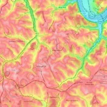
Name: Baldwin topographic map, elevation, terrain.
Average elevation: 1,109 ft
Minimum elevation: 712 ft
Maximum elevation: 1,302 ft
Allegheny County trails, hiking, mountain biking, running and outdoor activities
Other topographic maps
Click on a map to view its topography, its elevation and its terrain.
Allison Park
United States > Pennsylvania > Allegheny County > Hampton Township
Average elevation: 1,063 ft
New England
United States > Pennsylvania > Allegheny County > West Mifflin
Average elevation: 1,093 ft
Morgan
United States > Pennsylvania > Allegheny County > South Fayette Township
Average elevation: 1,030 ft
Rural Ridge
United States > Pennsylvania > Allegheny County > Indiana Township
Average elevation: 1,079 ft
Cuddy Hill
United States > Pennsylvania > Allegheny County > South Fayette Township
Average elevation: 1,076 ft
Indianola
United States > Pennsylvania > Allegheny County > Indiana Township
Average elevation: 1,014 ft
Rennerdale
United States > Pennsylvania > Allegheny County > Collier Township
Average elevation: 1,053 ft
Noblestown
United States > Pennsylvania > Allegheny County > North Fayette Township
Average elevation: 1,089 ft
Industry
United States > Pennsylvania > Allegheny County > Elizabeth Township
Average elevation: 958 ft
Greenock
United States > Pennsylvania > Allegheny County > Elizabeth Township
Average elevation: 945 ft
Enlow
United States > Pennsylvania > Allegheny County > North Fayette Township
Average elevation: 1,079 ft
Dorseyville
United States > Pennsylvania > Allegheny County > Indiana Township
Average elevation: 1,066 ft
Bairdford
United States > Pennsylvania > Allegheny County > West Deer Township
Average elevation: 1,079 ft
Buena Vista
United States > Pennsylvania > Allegheny County > Elizabeth Township
Average elevation: 955 ft
Beadling
United States > Pennsylvania > Allegheny County > Upper St. Clair
Average elevation: 1,070 ft
Groveton
United States > Pennsylvania > Allegheny County > Robinson Township
Average elevation: 876 ft
Gibsonia
United States > Pennsylvania > Allegheny County > Richland Township
Average elevation: 1,142 ft
Elfinwild
United States > Pennsylvania > Allegheny County > Shaler Township
Average elevation: 1,056 ft
Wildwood
United States > Pennsylvania > Allegheny County > Hampton Township
Average elevation: 1,079 ft
Panther Hollow Lake
United States > Pennsylvania > Allegheny County > Pittsburgh
Average elevation: 938 ft
Santiago
United States > Pennsylvania > Allegheny County > North Fayette Township
Average elevation: 1,161 ft
Lovedale
United States > Pennsylvania > Allegheny County > Elizabeth Township
Average elevation: 978 ft
Mount Vernon
United States > Pennsylvania > Allegheny County > Elizabeth Township
Average elevation: 981 ft
Talley Cavey
United States > Pennsylvania > Allegheny County > Hampton Township
Average elevation: 1,119 ft
Piney Fork
United States > Pennsylvania > Allegheny County > South Park Township
Average elevation: 1,066 ft
Fox Ridge
United States > Pennsylvania > Allegheny County > McCandless > Fox Ridge
Average elevation: 1,145 ft
Black mulberry (Morus nigra)
United States > Pennsylvania > Allegheny County > Pittsburgh
Average elevation: 971 ft