Geolocate

Utley topographic map

Click on the map to display elevation.

About this map

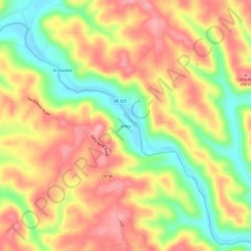
Name: Utley topographic map, elevation, terrain.

Location: Utley, Athens County, Ohio, 45711, United States (39.36702 -81.92986 39.40702 -81.88986)

Average elevation: 814 ft

Minimum elevation: 600 ft

Maximum elevation: 974 ft

Athens County trails, hiking, mountain biking, running and outdoor activities

Other topographic maps

Click on a map to view its topography, its elevation and its terrain.

Buchtel

United States > Ohio > Athens County

Average elevation: 781 ft

Pratts Fork

United States > Ohio > Athens County > Athens

Average elevation: 833 ft

Trimble

United States > Ohio > Athens County

Average elevation: 778 ft

Chauncey

United States > Ohio > Athens County

Average elevation: 715 ft

Jacksonville

United States > Ohio > Athens County

Average elevation: 768 ft

Athens

United States > Ohio > Athens County

Average elevation: 787 ft

Canaan Township

United States > Ohio > Athens County

Average elevation: 814 ft

Coolville

United States > Ohio > Athens County

Average elevation: 696 ft

Amesville

United States > Ohio > Athens County

Amesville is situated in the foothills of the Appalachian Mountains, approximately 45 miles south by southeast of the terminal moraine, a topographical feature often associated with the boundaries of glaciers, and is surrounded by wooded hills, narrow valleys, and numerous creeks flanked by lowland pastures…

Average elevation: 732 ft

Albany

United States > Ohio > Athens County

Average elevation: 771 ft

Gear up for your next adventure:

👟Trail Running Shoes - Lightweight shoes for trail runners
🏔️Mountain Trail Maps - High‑detail maps for popular peaks
🔦LED Headlamp - Bright and durable LED headlamp for night navigation
🎒Gear Packing Cubes - Organize your backpack efficiently
🦺Reflective Outdoor Gear - Safety gear for low‑light conditions

As an Amazon Associate, this site earns from qualifying purchases at no extra cost to you.