
Barnes Lake topographic map
Click on the map to display elevation.
About this map
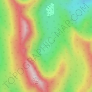
Name: Barnes Lake topographic map, elevation, terrain.
Average elevation: 6,801 ft
Minimum elevation: 5,715 ft
Maximum elevation: 7,989 ft
Other topographic maps
Click on a map to view its topography, its elevation and its terrain.
Mount Fernie
Canada > British Columbia > Regional District of East Kootenay > Area A (Upper Flathead/Elk Valley)
Average elevation: 5,919 ft
Mount Fernie Provincial Park
Canada > British Columbia > Regional District of East Kootenay > Area A (Upper Flathead/Elk Valley)
Average elevation: 3,635 ft
Mount Erickson
Canada > British Columbia > Regional District of East Kootenay > Area A (Upper Flathead/Elk Valley)
Average elevation: 6,358 ft
Mount Strachan
Canada > British Columbia > Regional District of East Kootenay > Area A (Upper Flathead/Elk Valley)
Average elevation: 7,211 ft
Grizzly Peak
Canada > British Columbia > Regional District of East Kootenay > Area A (Upper Flathead/Elk Valley)
Average elevation: 6,437 ft
Island Lake
Canada > British Columbia > Regional District of East Kootenay > Area A (Upper Flathead/Elk Valley)
Average elevation: 4,957 ft
Tent Mountain
Canada > British Columbia > Regional District of East Kootenay > Area A (Upper Flathead/Elk Valley)
Average elevation: 6,145 ft
Rocky Mountains
Canada > British Columbia > Regional District of East Kootenay > Area A (Upper Flathead/Elk Valley)
Average elevation: 7,083 ft
Rocky Mountains
Canada > British Columbia > Regional District of East Kootenay > Area A (Upper Flathead/Elk Valley)
Average elevation: 7,083 ft
Mount Strachan
Canada > British Columbia > Regional District of East Kootenay > Area A (Upper Flathead/Elk Valley)
Average elevation: 7,211 ft