
Clarksville topographic map
Click on the map to display elevation.
About this map
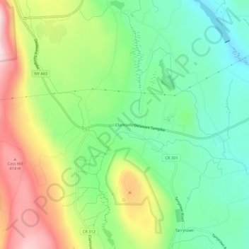
Name: Clarksville topographic map, elevation, terrain.
Average elevation: 797 ft
Minimum elevation: 361 ft
Maximum elevation: 1,496 ft
Albany County trails, hiking, mountain biking, running and outdoor activities
Other topographic maps
Click on a map to view its topography, its elevation and its terrain.
John Boyd Thacher State Park
United States > New York > Albany County > Town of New Scotland
The escarpment features rocks of the Upper Silurian and Upper and Middle Ordovician ages resting below the Devonian rocks. At the base of the escarpment, the Schenectady beds are visible. The Rondout "waterlime" or dolomite overlies the Schenectady beds and is most pronounced below Minelot Falls. The…
Average elevation: 860 ft