Geolocate

Eustis topographic map

Click on the map to display elevation.

About this map

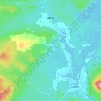
Name: Eustis topographic map, elevation, terrain.

Location: Eustis, Franklin County, Maine, United States (45.12545 -70.56638 45.23660 -70.41723)

Average elevation: 1,355 ft

Minimum elevation: 1,129 ft

Maximum elevation: 2,687 ft

Franklin County trails, hiking, mountain biking, running and outdoor activities

Other topographic maps

Click on a map to view its topography, its elevation and its terrain.

Mount Blue

United States > Maine > Franklin County > Avon

Average elevation: 2,080 ft

Dryden

United States > Maine > Franklin County > Wilton

Average elevation: 541 ft

East Dixfield

United States > Maine > Franklin County > Wilton

Average elevation: 745 ft

East Wilton

United States > Maine > Franklin County > Wilton

Average elevation: 545 ft

Sandy River

United States > Maine > Franklin County > Madrid Township

Average elevation: 1,073 ft

Webb Lake

United States > Maine > Franklin County > Weld

Average elevation: 810 ft

Gordon Hill

United States > Maine > Franklin County > Chesterville

Average elevation: 495 ft

Stratton

United States > Maine > Franklin County > Eustis > Stratton

Average elevation: 1,227 ft

Gear up for your next adventure:

Backpacking Tents - Weight-optimized shelters for multi-day topographic surveys
🧺Microfiber Travel Towels - Compact and fast-drying towels for trail use
📱Heavy-Duty Phone Cases - Drop-proof and waterproof protection for outdoor navigation
🧴Hand Sanitizer - Keep hands clean while hiking
🧣Hiking Neck Gaiter - Multi‑use neck protection for outdoor weather

As an Amazon Associate, this site earns from qualifying purchases at no extra cost to you.