Geolocate

Hunter topographic map

Click on the map to display elevation.

About this map

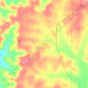
Name: Hunter topographic map, elevation, terrain.

Location: Hunter, Carter County, Missouri, United States (36.87061 -90.86901 36.91061 -90.82901)

Average elevation: 735 ft

Minimum elevation: 538 ft

Maximum elevation: 840 ft

Carter County trails, hiking, mountain biking, running and outdoor activities

Other topographic maps

Click on a map to view its topography, its elevation and its terrain.

Van Buren

United States > Missouri > Carter County

Average elevation: 561 ft

Grandin

United States > Missouri > Carter County

Average elevation: 650 ft

Ellsinore

United States > Missouri > Carter County

Average elevation: 768 ft

Gear up for your next adventure:

🎁Geography Themed Gifts - Unique gift ideas for map lovers and geography enthusiasts
Backpacking Tent - Lightweight and durable tent for multi‑day hikes
🪶Thermal Camp Blanket - Extra warmth for cold nights
🛡️Bear Spray Outdoor - Protection in bear country hikes
🪶Camp Gear Gift Set - Perfect gift bundle for outdoor fans

As an Amazon Associate, this site earns from qualifying purchases at no extra cost to you.