Geolocate

Wrenshall topographic map

Click on the map to display elevation.

About this map

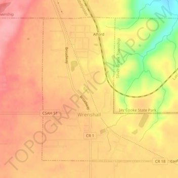
Name: Wrenshall topographic map, elevation, terrain.

Location: Wrenshall, Carlton County, Minnesota, United States (46.61258 -92.39609 46.63448 -92.36438)

Average elevation: 1,033 ft

Minimum elevation: 794 ft

Maximum elevation: 1,145 ft

Carlton County trails, hiking, mountain biking, running and outdoor activities

Other topographic maps

Click on a map to view its topography, its elevation and its terrain.

Atkinson

United States > Minnesota > Carlton County

Average elevation: 1,158 ft

Esko

United States > Minnesota > Carlton County

Average elevation: 1,181 ft

Automba

United States > Minnesota > Carlton County

Average elevation: 1,280 ft

Holyoke

United States > Minnesota > Carlton County

Average elevation: 1,024 ft

Mahtowa

United States > Minnesota > Carlton County

Average elevation: 1,168 ft

Perch Lake

United States > Minnesota > Carlton County

Average elevation: 1,309 ft

Thomson

United States > Minnesota > Carlton County > Carlton

Average elevation: 1,073 ft

Corona

United States > Minnesota > Carlton County

Average elevation: 1,299 ft

Duesler

United States > Minnesota > Carlton County

Average elevation: 1,020 ft

Harney

United States > Minnesota > Carlton County

Average elevation: 1,194 ft

Iverson

United States > Minnesota > Carlton County

Average elevation: 1,220 ft

Gear up for your next adventure:

🔋Solar Power Banks - Keep your GPS and phone charged in remote wilderness areas
🪶Multi‑Purpose Knife - Useful blade for camp and trail
🕶️GPS Smartphone Mount - Secure mount for phone navigation
🧦Hiking Socks - Comfortable socks to prevent blisters on long hikes
🌎3D Topographic Globes - Raised relief globes for a tactile understanding of geography

As an Amazon Associate, this site earns from qualifying purchases at no extra cost to you.