
Make a donation
Gear up for your next adventure:
As an Amazon Associate, this site earns from qualifying purchases at no extra cost to you.
Raystown Lake topographic map
Click on the map to display elevation.
Make a donation
Gear up for your next adventure:
As an Amazon Associate, this site earns from qualifying purchases at no extra cost to you.
Raystown Lake
The proposal for the new dam incorporated the ideas of bringing tourism into the area, promoting recreation, and flood control. The actual purpose stated, "The project will provide flood control, recreation, water quality and fish and wildlife enhancement" (U.S. Army Corps of Engineers, 1974). Although tourism and recreation was what was projected as the most important to the public and community, the reason the dam was approved was for flood control. The project was authorized under the general provisions of the Flood Control Act of 1962 (Public Law 87-874, 87th Congress, second session). The dam has a flood storage capacity of 247,900 acre-feet (305,800,000 m3), equivalent to about 5 inches (13 cm) of runoff from the drainage area of 960 square miles (2,500 km2) above the dam, between elevations of 786 and 812 (U.S. Army Corps of Engineers, 1965). "The project would reduce flood stages along the Juniata River at Mount Union, Lewistown, Mifflin, and Newport, Pennsylvania, and to a lesser extent, along the main stem of the Susquehanna River below the mouth of the Juniata River" (U.S. Army Corps of Engineers, 1965).
Make a donation
Gear up for your next adventure:
As an Amazon Associate, this site earns from qualifying purchases at no extra cost to you.
About this map
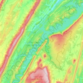
Name: Raystown Lake topographic map, elevation, terrain.
Average elevation: 1,247 ft
Minimum elevation: 676 ft
Maximum elevation: 2,336 ft
Huntingdon County trails, hiking, mountain biking, running and outdoor activities
Make a donation
Gear up for your next adventure:
As an Amazon Associate, this site earns from qualifying purchases at no extra cost to you.
Other topographic maps
Click on a map to view its topography, its elevation and its terrain.
Entriken
United States > Pennsylvania > Huntingdon County > Lincoln Township
Average elevation: 1,063 ft