
Dildo topographic map
Click on the map to display elevation.
About this map
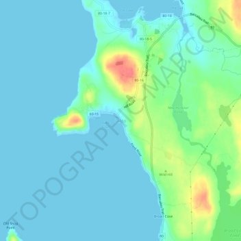
Name: Dildo topographic map, elevation, terrain.
Average elevation: 39 ft
Minimum elevation: -10 ft
Maximum elevation: 197 ft
Other topographic maps
Click on a map to view its topography, its elevation and its terrain.
Terra Nova National Park
Canada > Newfoundland and Labrador > unincorporated Newfoundland
Terra Nova's landscape is typical of the northeast coast of Newfoundland, but with remnants of the Appalachian Mountains contributing to widely varied and rugged topography throughout the region. The park's seacoast consists of several rocky "fingers" jutting into Bonavista Bay along an area stretching from…
Average elevation: 190 ft
Trinity Bay
Canada > Newfoundland and Labrador > unincorporated Newfoundland
Average elevation: 174 ft
Pistolet Bay Provincial Park
Canada > Newfoundland and Labrador > unincorporated Newfoundland
Average elevation: 69 ft
Pistolet Bay Provincial Park
Canada > Newfoundland and Labrador > unincorporated Newfoundland
Average elevation: 69 ft