
Make a donation
Gear up for your next adventure:
As an Amazon Associate, this site earns from qualifying purchases at no extra cost to you.
Lac Brûlé topographic map
Click on the map to display elevation.
Make a donation
Gear up for your next adventure:
As an Amazon Associate, this site earns from qualifying purchases at no extra cost to you.
About this map
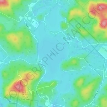
Name: Lac Brûlé topographic map, elevation, terrain.
Average elevation: 1,283 ft
Minimum elevation: 1,181 ft
Maximum elevation: 1,598 ft
Make a donation
Gear up for your next adventure:
As an Amazon Associate, this site earns from qualifying purchases at no extra cost to you.
Other topographic maps
Click on a map to view its topography, its elevation and its terrain.
Mont Sainte-Agathe
Canada > Quebec > Les Laurentides > Sainte-Agathe-des-Monts
Average elevation: 1,470 ft
Lac-à-la-Truite
Canada > Quebec > Les Laurentides > Sainte-Agathe-des-Monts
Average elevation: 1,339 ft
Mont Catherine
Canada > Quebec > Les Laurentides > Sainte-Agathe-des-Monts
Average elevation: 1,352 ft