
Starr topographic map
Click on the map to display elevation.
About this map
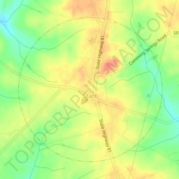
Name: Starr topographic map, elevation, terrain.
Location: Starr, Anderson County, South Carolina, United States (34.36710 -82.70874 34.38884 -82.68246)
Average elevation: 745 ft
Minimum elevation: 650 ft
Maximum elevation: 820 ft
Anderson County trails, hiking, mountain biking, running and outdoor activities
Other topographic maps
Click on a map to view its topography, its elevation and its terrain.
Homeland Park
United States > South Carolina > Anderson County > Varennes Heights
Average elevation: 768 ft
Centerville
United States > South Carolina > Anderson County > Gilmer Estates
Average elevation: 791 ft
Sweet Gum Trail
United States > South Carolina > Anderson County > Sweet Gum Trail
Average elevation: 745 ft
Huntington Hills
United States > South Carolina > Anderson County > Huntington Hills
Average elevation: 774 ft
Pendleton Gardens
United States > South Carolina > Anderson County > Pendleton
Average elevation: 787 ft
Caldwell Village
United States > South Carolina > Anderson County > Anderson
Average elevation: 758 ft