Make a donation
Gear up for your next adventure:
As an Amazon Associate, this site earns from qualifying purchases at no extra cost to you.
Roanoke topographic map
Click on the map to display elevation.
Make a donation
Gear up for your next adventure:
As an Amazon Associate, this site earns from qualifying purchases at no extra cost to you.
About this map
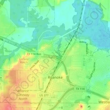
Name: Roanoke topographic map, elevation, terrain.
Location: Roanoke, Denton County, Texas, 76262, United States (32.98695 -97.25795 33.04407 -97.19552)
Average elevation: 610 ft
Minimum elevation: 538 ft
Maximum elevation: 741 ft
Denton County trails, hiking, mountain biking, running and outdoor activities
Make a donation
Gear up for your next adventure:
As an Amazon Associate, this site earns from qualifying purchases at no extra cost to you.
Other topographic maps
Click on a map to view its topography, its elevation and its terrain.
Clear Creek Natural Heritage Center
United States > Texas > Denton County > Denton
Average elevation: 568 ft
Make a donation
Gear up for your next adventure:
As an Amazon Associate, this site earns from qualifying purchases at no extra cost to you.
Lewisville
United States > Texas > Denton County > Lewisville
Lewisville is at 33°2′18″N 97°0′22″W / 33.03833°N 97.00611°W / 33.03833; -97.00611 (33.038316, −97.006232) at an elevation of about 550 feet (170 m). It has a total area of 42.47 square miles (110.0 km2), of which 36.4 sq mi (94 km2) is land. It lies at the southern end of Denton County…
Average elevation: 571 ft
Make a donation
Gear up for your next adventure:
As an Amazon Associate, this site earns from qualifying purchases at no extra cost to you.
Lakewood Village
United States > Texas > Denton County > Lakewood Village > Lakewood Village
Average elevation: 535 ft
