Sheridan topographic map
Interactive map
Click on the map to display elevation.
About this map
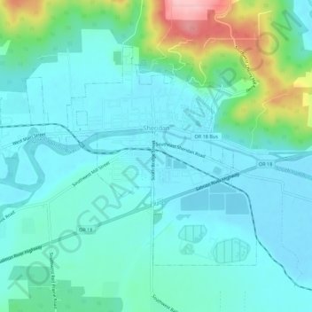
Name: Sheridan topographic map, elevation, terrain.
Location: Sheridan, Yamhill County, Oregon, United States (45.08207 -123.43244 45.10937 -123.37708)
Average elevation: 279 ft
Minimum elevation: 171 ft
Maximum elevation: 712 ft
The South Yamhill River divides the city between north and south, and is prone to flooding the city. Deer Creek is the only other stream in the city. Sheridan is located in the western part of the Willamette Valley at an elevation of 189 feet (58 m) above sea level. The city lies at the foothills of the Northern Oregon Coast Range.
Other topographic maps
Click on a map to view its topography, its elevation and its terrain.
McMinnville
United States > Oregon > Yamhill County
McMinnville, Yamhill County, Oregon, 97128, United States
Average elevation: 164 ft
Newberg
United States > Oregon > Yamhill County
Newberg, Yamhill County, Oregon, United States
Average elevation: 200 ft
Lafayette
United States > Oregon > Yamhill County
Lafayette, Yamhill County, Oregon, 97127, United States
Average elevation: 171 ft
McGuire Reservoir
United States > Oregon > Yamhill County
McGuire Reservoir, Yamhill County, Oregon, United States
Average elevation: 1,909 ft
Bald Peak State Scenic Viewpoint
United States > Oregon > Yamhill County
Bald Peak State Scenic Viewpoint, Southwest Bald Peak Road, Yamhill County, Oregon, United States
Average elevation: 1,096 ft
Carlton
United States > Oregon > Yamhill County
Carlton, Yamhill County, Oregon, 97111, United States
Average elevation: 167 ft
Amity
United States > Oregon > Yamhill County
Amity, Yamhill County, Oregon, United States
Average elevation: 167 ft
Dayton
United States > Oregon > Yamhill County
Dayton, Yamhill County, Oregon, United States
Average elevation: 141 ft
Dundee
United States > Oregon > Yamhill County
Dundee, Yamhill County, Oregon, 97115, United States
Average elevation: 226 ft
Willamina
United States > Oregon > Yamhill County > Willamina
Willamina, Yamhill County, Oregon, United States
Average elevation: 305 ft
Yamhill
United States > Oregon > Yamhill County > Yamhill
Yamhill, Yamhill County, Oregon, United States
Average elevation: 180 ft
Tetons
United States > Oregon > Yamhill County
Tetons, Yamhill County, Oregon, United States
Average elevation: 1,332 ft