Geolocate

Saint Charles topographic map

Click on the map to display elevation.

About this map

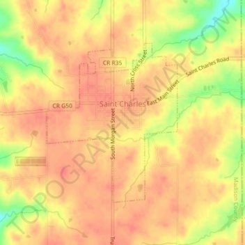
Name: Saint Charles topographic map, elevation, terrain.

Location: Saint Charles, Madison County, Iowa, United States (41.27747 -93.81840 41.29503 -93.79919)

Average elevation: 1,037 ft

Minimum elevation: 912 ft

Maximum elevation: 1,079 ft

Madison County trails, hiking, mountain biking, running and outdoor activities

Other topographic maps

Click on a map to view its topography, its elevation and its terrain.

Patterson

United States > Iowa > Madison County > Patterson > Patterson

Average elevation: 945 ft

Gear up for your next adventure:

🪄Magnetic Compass - Accurate compass for navigation
📱Solar Portable Charger - Solar power bank for charging devices off‑grid
🪶LED Camping Lantern - Bright lantern for camp lighting
🛌Ultralight Sleeping Bags - Compact down bags for cold nights in the wilderness
❄️Traction Cleats - Prevent slips on icy trails during winter hikes

As an Amazon Associate, this site earns from qualifying purchases at no extra cost to you.