Geolocate
👉 Easily get elevation data in JSON, GeoTIFF and KML formats using Elevation API
Thank you for supporting this site ❤️
Make a donation

Belleville topographic map

Click on the map to display elevation.

About this map

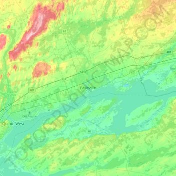
Name: Belleville topographic map, elevation, terrain.

Location: Belleville, Central Ontario, Ontario, K8N 2Z2, Canada (44.00333 -77.54526 44.32333 -77.22526)

Average elevation: 351 ft

Minimum elevation: 190 ft

Maximum elevation: 774 ft

Gear up for your next adventure:

🧼Biodegradable Camping Soap - Eco‑friendly soap for outdoor hygiene
📡Handheld GPS Device - Reliable handheld GPS for outdoor navigation
🔦Powerful Headlamps - Ultra-bright hands-free lighting for night navigation
🔭Telescopic Hiking Pole - Adjustable pole for hiking stability
🛠️Backpacking Tool Kit - Essential toolkit for outdoor repairs

As an Amazon Associate, this site earns from qualifying purchases at no extra cost to you.