
Make a donation
Gear up for your next adventure:
As an Amazon Associate, this site earns from qualifying purchases at no extra cost to you.
Straubenhardt topographic map
Click on the map to display elevation.
Make a donation
Gear up for your next adventure:
As an Amazon Associate, this site earns from qualifying purchases at no extra cost to you.
Straubenhardt
Die Gemeinde hat Anteil an den Naturschutzgebieten Pfinzquellen, Albtal und Seitentäler, Mistwiesen und Eyach- und Rotenbachtal. Außerdem liegen auf dem Gemeindegebiet die Landschaftsschutzgebiete Albtalplatten und Herrenalber Berge und Straubenhardter Schwarzwaldrandhöhe. Das gesamte Gemeindegebiet liegt im Naturpark Schwarzwald Mitte/Nord.
Make a donation
Gear up for your next adventure:
As an Amazon Associate, this site earns from qualifying purchases at no extra cost to you.
About this map
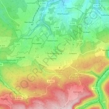
Name: Straubenhardt topographic map, elevation, terrain.
Location: Straubenhardt, Enzkreis, Baden-Württemberg, 75334, Deutschland (48.80974 8.46806 48.88245 8.56912)
Average elevation: 1,371 ft
Minimum elevation: 745 ft
Maximum elevation: 2,267 ft
Make a donation
Gear up for your next adventure:
As an Amazon Associate, this site earns from qualifying purchases at no extra cost to you.
Other topographic maps
Click on a map to view its topography, its elevation and its terrain.
Stein
Deutschland > Baden-Württemberg > Enzkreis
Königsbach-Stein liegt etwa zwölf Kilometer nordwestlich der Kreisstadt Pforzheim und etwa 20 km östlich von Karlsruhe zwischen Kraichgau und Nordschwarzwald in 177 bis 330 Metern Höhe.
Average elevation: 791 ft
Make a donation
Gear up for your next adventure:
As an Amazon Associate, this site earns from qualifying purchases at no extra cost to you.
Make a donation
Gear up for your next adventure:
As an Amazon Associate, this site earns from qualifying purchases at no extra cost to you.
Make a donation
Gear up for your next adventure:
As an Amazon Associate, this site earns from qualifying purchases at no extra cost to you.
Zaisersweiher
Deutschland > Baden-Württemberg > Enzkreis > Maulbronn
Maulbronn verfügt mit dem Bahnhof Maulbronn West seit 1853 über eine ca. 3,5 km von Stadtzentrum entfernt im Wald gelegene Station an der Westbahn Bietigheim-Bissingen–Bruchsal. Diese ungünstige Bahnhofslage hat topografische Gründe. Die Westbahn erhielt einen Tunnel südlich des Bahnhofs (Name nach dem…
Average elevation: 965 ft
Make a donation
Gear up for your next adventure:
As an Amazon Associate, this site earns from qualifying purchases at no extra cost to you.
Königsbach
Deutschland > Baden-Württemberg > Enzkreis
Königsbach-Stein liegt etwa zwölf Kilometer nordwestlich der Kreisstadt Pforzheim und etwa 20 km östlich von Karlsruhe zwischen Kraichgau und Nordschwarzwald in 177 bis 330 Metern Höhe.
Average elevation: 715 ft
Make a donation
Gear up for your next adventure:
As an Amazon Associate, this site earns from qualifying purchases at no extra cost to you.
Schellbronn
Deutschland > Baden-Württemberg > Enzkreis
Die Gemeindefläche ist in Triasschichten gelegen. Aufgrund der Höhenlage zwischen Nagold- und Würmtal auf den nordöstlichen Schwarzwald-Randplatten dominiert der Obere Buntsandstein, der vereinzelt von Unterem Muschelkalk überlagert wird. Südlich grenzt an Neuhausen das Gäuland mit Unterem und Mittlerem…
Average elevation: 1,542 ft
Make a donation
Gear up for your next adventure:
As an Amazon Associate, this site earns from qualifying purchases at no extra cost to you.
Make a donation
Gear up for your next adventure:
As an Amazon Associate, this site earns from qualifying purchases at no extra cost to you.
Make a donation
Gear up for your next adventure:
As an Amazon Associate, this site earns from qualifying purchases at no extra cost to you.