
Thank you for supporting this site ❤️
Make a donation
Make a donation
Gear up for your next adventure:
As an Amazon Associate, this site earns from qualifying purchases at no extra cost to you.
Lagunillas topographic map
Click on the map to display elevation.
Thank you for supporting this site ❤️
Make a donation
Make a donation
Gear up for your next adventure:
As an Amazon Associate, this site earns from qualifying purchases at no extra cost to you.
About this map
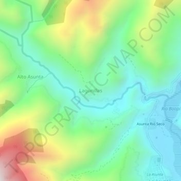
Name: Lagunillas topographic map, elevation, terrain.
Average elevation: 3,458 ft
Minimum elevation: 2,195 ft
Maximum elevation: 6,178 ft
Thank you for supporting this site ❤️
Make a donation
Make a donation
Gear up for your next adventure:
As an Amazon Associate, this site earns from qualifying purchases at no extra cost to you.
Other topographic maps
Click on a map to view its topography, its elevation and its terrain.
Rio Boopi
Bolivia > La Paz > Provincia Sud Yungas > Municipio La Asunta > Alto Olivos (disperso)
Average elevation: 2,533 ft
Conchita Chico
Bolivia > La Paz > Provincia Sud Yungas > Municipio La Asunta
Average elevation: 5,597 ft