
Rocky Point topographic map
Click on the map to display elevation.
About this map
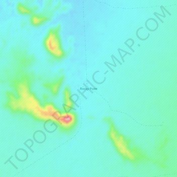
Name: Rocky Point topographic map, elevation, terrain.
Location: Rocky Point, Maricopa County, Arizona, United States (32.51367 -112.86821 32.55367 -112.82821)
Average elevation: 1,299 ft
Minimum elevation: 1,220 ft
Maximum elevation: 1,706 ft
Other topographic maps
Click on a map to view its topography, its elevation and its terrain.
Phoenix
United States > Arizona > Maricopa County
Phoenix is characterized by a unique topographical landscape nestled in the Salt River Valley. This valley, at an average elevation of about 1,086 feet, is framed by several prominent mountain ranges, creating a striking contrast between the flat plains and elevated terrains. Notable peaks such as Camelback…
Average elevation: 1,578 ft
Phoenix
United States > Arizona > Maricopa County
Phoenix is in the southwestern United States, in the south-central portion of Arizona; about halfway between Tucson to the southeast and Flagstaff to the north. By car, the city is approximately 150 miles (240 kilometers) north of the US-Mexico border at Sonoyta and 180 mi (290 km) north of the border at…
Average elevation: 1,578 ft
Scottsdale
United States > Arizona > Maricopa County
Scottsdale features a diverse topography shaped by its location within the Sonoran Desert and the foothills of the McDowell Mountains. The city sits at an average elevation of about 1,827 feet (558 meters), with a range that spans from approximately 1,052 feet (321 meters) at its lowest points to 4,819 feet…
Average elevation: 1,814 ft
Cave Creek
United States > Arizona > Maricopa County
Cave Creek is a town in the Sonoran Desert. It sits in northern Maricopa County on the northern edge of Paradise Valley, with mountains rising to the north that eventually connect with the New River Mountains and the Black Hills. It is 33 miles (53 km) north of downtown Phoenix, although the Phoenix city…
Average elevation: 2,438 ft
Fountain Hills
United States > Arizona > Maricopa County
Fountain Hills is in eastern Maricopa County, on the eastern edge of the Phoenix urbanized area. It is 31 miles (50 km) northeast of downtown Phoenix and sits on the east side of the south end of the McDowell Mountains. According to the U.S. Census Bureau, the town has a total area of 20.4 square miles (53…
Average elevation: 1,650 ft
Tempe
United States > Arizona > Maricopa County
Tempe is generally flat, except for Tempe Butte or Hayden Butte (generally known as A-Mountain for Arizona State University's "A" logo located on its south face), located next to Sun Devil Stadium, Twin Buttes and Bell Butte on the western edge of Tempe, and the buttes within Papago Park at northwest corner of…
Average elevation: 1,214 ft
Gilbert
United States > Arizona > Maricopa County
Gilbert is characterized by a relatively flat terrain typical of the Sonoran Desert region. The town sits at an elevation of approximately 1,237 feet (377 meters) above sea level, with minor fluctuations in topography across its 68.86 square miles. The landscape primarily features arid desert terrain, dotted…
Average elevation: 1,257 ft
Peoria
United States > Arizona > Maricopa County
Peoria, located in Maricopa County, Arizona, is set within the expansive Salt River Valley. The city's terrain is generally flat, with an average elevation of around 1,122 feet (342 meters) above sea level. However, as you move northward, the landscape gradually transitions into the foothills of the…
Average elevation: 1,657 ft
Anthem
United States > Arizona > Maricopa County > Anthem
Anthem is built on 5,856 acres (9.2 sq mi) at the base of Daisy Mountain and Gavilan Peak in northern Maricopa County. The CDP portion of Anthem has an area of 7.9 square miles (20 km2). The community's elevation ranges from 1,760 to 2,428 feet (536 to 740 m), with an average elevation of 1,863 feet (568 m).…
Average elevation: 1,906 ft
Gila Bend
United States > Arizona > Maricopa County
According to the United States Census Bureau, the town has a total area of 64.4 square miles (167 km2), all of it land. Situated at 735 feet (224 m) above sea level, Gila Bend has the lowest elevation of any city in Maricopa County and in Greater Phoenix overall.
Average elevation: 843 ft
Carefree
United States > Arizona > Maricopa County
Carefree is in northeastern Maricopa County, bordered by the city of Scottsdale to the south and east and by the town of Cave Creek to the west. Carefree and Cave Creek are sometimes thought of as a single community. The two towns share the local landmark Black Mountain, which rises more than 1,000 feet (300…
Average elevation: 2,451 ft
Komatke
United States > Arizona > Maricopa County > Komatke
Saint John the Baptist Parish Laveen, the Saint Johns Mission, is in Komatke. The name is taken from the mission school founded by the Franciscans in 1894. It has an estimated elevation of 1,030 feet (310 m) above sea level.
Average elevation: 1,099 ft
Phoenix
United States > Arizona > Maricopa County
Phoenix is in the south-central portion of Arizona; about halfway between Tucson to the southeast and Flagstaff to the north, in the southwestern United States. By car, the city is approximately 150 miles (240 kilometers) north of the US–Mexico border at Sonoyta and 180 mi (290 km) north of the border at…
Average elevation: 1,578 ft
Fountain Hills
United States > Arizona > Maricopa County
Fountain Hills is in eastern Maricopa County, on the eastern edge of the Phoenix urbanized area. It is 31 miles (50 km) northeast of downtown Phoenix and sits on the east side of the south end of the McDowell Mountains. According to the U.S. Census Bureau, the town has a total area of 20.4 square miles (53…
Average elevation: 1,650 ft
Carefree
United States > Arizona > Maricopa County
Carefree is in northeastern Maricopa County, bordered by the city of Scottsdale to the south and east and by the town of Cave Creek to the west. Carefree and Cave Creek are sometimes thought of as a single community. The two towns share the local landmark Black Mountain, which rises more than 1,000 feet (300…
Average elevation: 2,451 ft
Fountain Hills
United States > Arizona > Maricopa County
Fountain Hills is in eastern Maricopa County, on the eastern edge of the Phoenix urbanized area. It is 31 miles (50 km) northeast of downtown Phoenix and sits on the east side of the south end of the McDowell Mountains. According to the U.S. Census Bureau, the town has a total area of 20.4 square miles (53…
Average elevation: 1,650 ft
Cave Creek
United States > Arizona > Maricopa County
Cave Creek is a town in the Sonoran Desert. It sits in northern Maricopa County on the northern edge of Paradise Valley, with mountains rising to the north that eventually connect with the New River Mountains and the Black Hills. It is 33 miles (53 km) north of downtown Phoenix, although the Phoenix city…
Average elevation: 2,438 ft
Cave Creek
United States > Arizona > Maricopa County
Cave Creek is a town in the Sonoran Desert. It sits in northern Maricopa County on the northern edge of Scottsdale, with mountains rising to the north that eventually connect with the New River Mountains and the Black Hills. It is 33 miles (53 km) north of downtown Phoenix, although the Phoenix city limits…
Average elevation: 2,438 ft
Gila Bend
United States > Arizona > Maricopa County
According to the United States Census Bureau, the town has a total area of 64.4 square miles (167 km2), all of it land. Situated at 735 feet (224 m) above sea level, Gila Bend has the lowest elevation of any city in Maricopa County and in Greater Phoenix overall.
Average elevation: 843 ft
Phoenix
United States > Arizona > Maricopa County
Phoenix is in the south-central portion of Arizona; about halfway between Tucson to the southeast and Flagstaff to the north, in the southwestern United States. By car, the city is approximately 150 miles (240 kilometers) north of the US–Mexico border at Sonoyta and 180 mi (290 km) north of the border at…
Average elevation: 1,578 ft
Scottsdale
United States > Arizona > Maricopa County
The city is in the Salt River Valley, or the "Valley of the Sun", in the northern reaches of the Sonoran Desert. Scottsdale, 31 miles (50 km) long and 11.4 miles (18.3 km) wide at its widest point, shares boundaries with many other municipalities and entities. On the west, Scottsdale is bordered by Phoenix,…
Average elevation: 1,814 ft
Scottsdale
United States > Arizona > Maricopa County
The city is in the Salt River Valley, or the "Valley of the Sun", in the northern reaches of the Sonoran Desert. Scottsdale, 31 mi (50 km) long and 11.4 mi (18.3 km) wide at its widest point, shares boundaries with many other municipalities and entities. On the west, Scottsdale is bordered by Phoenix, Paradise…
Average elevation: 1,814 ft
Tempe
United States > Arizona > Maricopa County
Tempe is generally flat, except for Tempe Butte or Hayden Butte (generally known as A-Mountain for Arizona State University's "A" logo located on its south face), located next to Sun Devil Stadium, Twin Buttes and Bell Butte on the western edge of Tempe, and the buttes within Papago Park at northwest corner of…
Average elevation: 1,214 ft
Scottsdale
United States > Arizona > Maricopa County
The city is in the Salt River Valley, or the "Valley of the Sun", in the northern reaches of the Sonoran Desert. Scottsdale, 31 mi (50 km) long and 11.4 mi (18.3 km) wide at its widest point, shares boundaries with many other municipalities and entities. On the west, Scottsdale is bordered by Phoenix, Paradise…
Average elevation: 1,814 ft
Scottsdale
United States > Arizona > Maricopa County
The city is in the Salt River Valley, or the "Valley of the Sun", in the northern reaches of the Sonoran Desert. Scottsdale, 31 miles (50 km) long and 11.4 miles (18.3 km) wide at its widest point, shares boundaries with many other municipalities and entities. On the west, Scottsdale is bordered by Phoenix,…
Average elevation: 1,814 ft
Tempe
United States > Arizona > Maricopa County
Tempe is generally flat, except for Tempe Butte or Hayden Butte (generally known as A-Mountain for Arizona State University's "A" logo located on its south face), located next to Sun Devil Stadium, Twin Buttes and Bell Butte on the western edge of Tempe, and the buttes within Papago Park at northwest corner of…
Average elevation: 1,214 ft
Fountain Hills
United States > Arizona > Maricopa County
Fountain Hills is in eastern Maricopa County, on the eastern edge of the Phoenix urbanized area. It is 31 miles (50 km) northeast of downtown Phoenix and sits on the east side of the south end of the McDowell Mountains. According to the U.S. Census Bureau, the town has a total area of 20.4 square miles (53…
Average elevation: 1,650 ft
Anthem
United States > Arizona > Maricopa County > Anthem
Anthem is built on 5,856 acres (9.2 sq mi) at the base of Daisy Mountain and Gavilan Peak in northern Maricopa County. The CDP portion of Anthem has an area of 7.9 square miles (20 km2). The community's elevation ranges from 1,760 to 2,428 feet (536 to 740 m), with an average elevation of 1,863 feet (568 m).…
Average elevation: 1,903 ft
Phoenix
United States > Arizona > Maricopa County
Phoenix is in the south-central portion of Arizona; about halfway between Tucson to the southeast and Flagstaff to the north, in the southwestern United States. By car, the city is approximately 150 miles (240 kilometers) north of the US–Mexico border at Sonoyta and 180 mi (290 km) north of the border at…
Average elevation: 1,578 ft
Tempe
United States > Arizona > Maricopa County
Tempe is generally flat, except for Tempe Butte or Hayden Butte (generally known as A-Mountain for Arizona State University's "A" logo located on its south face), located next to Sun Devil Stadium, Twin Buttes and Bell Butte on the western edge of Tempe, and the buttes within Papago Park at northwest corner of…
Average elevation: 1,214 ft
Phoenix
United States > Arizona > Maricopa County
Phoenix is in the south-central portion of Arizona; about halfway between Tucson to the southeast and Flagstaff to the north, in the Southwestern United States. By car, Phoenix is approximately 150 miles (240 kilometres) north of the US–Mexico border at Sonoyta and 180 mi (290 km) north of the border at…
Average elevation: 1,578 ft
Phoenix
United States > Arizona > Maricopa County
Phoenix is in the south-central portion of Arizona; about halfway between Tucson to the southeast and Flagstaff to the north, in the Southwestern United States. By car, the city is approximately 150 miles (240 kilometers) north of the US–Mexico border at Sonoyta and 180 mi (290 km) north of the border at…
Average elevation: 1,578 ft