
Make a donation
Gear up for your next adventure:
As an Amazon Associate, this site earns from qualifying purchases at no extra cost to you.
Argos topographic map
Click on the map to display elevation.
Make a donation
Gear up for your next adventure:
As an Amazon Associate, this site earns from qualifying purchases at no extra cost to you.
About this map
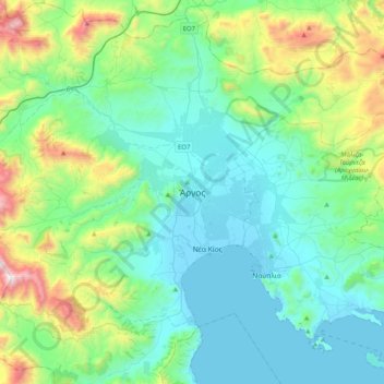
Name: Argos topographic map, elevation, terrain.
Average elevation: 1,056 ft
Minimum elevation: -7 ft
Maximum elevation: 5,157 ft
Make a donation
Gear up for your next adventure:
As an Amazon Associate, this site earns from qualifying purchases at no extra cost to you.
Other topographic maps
Click on a map to view its topography, its elevation and its terrain.
Municipal Unit of Kranidi
Greece > Peloponnese, Western Greece and the Ionian > Argolis Regional Unit
Average elevation: 495 ft
Municipal Unit of Argos
Greece > Peloponnese, Western Greece and the Ionian > Argolis Regional Unit
Average elevation: 696 ft
Municipal Unit of Kranidi
Greece > Peloponnese, Western Greece and the Ionian > Argolis Regional Unit
Average elevation: 495 ft
Municipal Unit of Kranidi
Greece > Peloponnese, Western Greece and the Ionian > Argolis Regional Unit
Average elevation: 495 ft
Make a donation
Gear up for your next adventure:
As an Amazon Associate, this site earns from qualifying purchases at no extra cost to you.
Municipal Unit of Nea Kios
Greece > Peloponnese, Western Greece and the Ionian > Argolis Regional Unit
Average elevation: 7 ft
Municipal Unit of Mykines
Greece > Peloponnese, Western Greece and the Ionian > Argolis Regional Unit
Average elevation: 1,024 ft