
Make a donation
Gear up for your next adventure:
As an Amazon Associate, this site earns from qualifying purchases at no extra cost to you.
Brochterbeck topographic map
Click on the map to display elevation.
Make a donation
Gear up for your next adventure:
As an Amazon Associate, this site earns from qualifying purchases at no extra cost to you.
Brochterbeck
Nachdem es infolge der Sommerunwetter im August 2010 in Höhe des Golfplatzes zu einem Dammrutsch gekommen ist, endet der „Teuto-Express“ aus Lengerich bereits in Tecklenburg und kann nicht länger über Brochterbeck bis Ibbenbüren Aasee fahren. Als nach einem Jahr die Gleise auch noch in Richtung Süden unterbrochen und vom neuen TWE-Eigentümer Captrain Deutschland nicht repariert wurden, gründete sich im Januar 2012 ein „Aktionsbündnis pro TWE“, das sich u. a. den langfristigen Erhalt und die regelmäßige Nutzung der Bahnstrecke Ibbenbüren–Hövelhof in den Bereichen Freizeit- und Tourismusverkehr zum Ziel gesetzt hat.
Make a donation
Gear up for your next adventure:
As an Amazon Associate, this site earns from qualifying purchases at no extra cost to you.
About this map
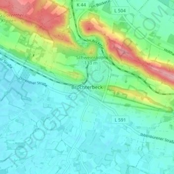
Name: Brochterbeck topographic map, elevation, terrain.
Average elevation: 269 ft
Minimum elevation: 164 ft
Maximum elevation: 581 ft
Make a donation
Gear up for your next adventure:
As an Amazon Associate, this site earns from qualifying purchases at no extra cost to you.
Other topographic maps
Click on a map to view its topography, its elevation and its terrain.
Brochterbecker Schlucht
Deutschland > Nordrhein-Westfalen > Kreis Steinfurt > Tecklenburg > Brochterbeck
Average elevation: 318 ft
Osterklee
Deutschland > Nordrhein-Westfalen > Kreis Steinfurt > Tecklenburg > Brochterbeck
Osterklee ist ein Naturschutzgebiet an der Grenze zwischen der Münsterländischen Tieflandsbucht und dem Weserbergland. Es erstreckt sich über 40 Hektar, etwa einen Kilometer östlich von Brochterbeck auf dem exponierten Kleeberg. Die exakte geographische Position ist 52° 13,75" nördliche Breite, 7°…
Average elevation: 285 ft