Geolocate

Kerrville topographic map

Click on the map to display elevation.

About this map

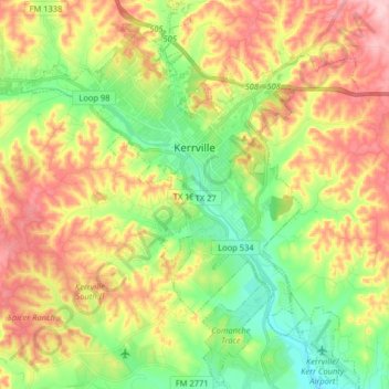
Name: Kerrville topographic map, elevation, terrain.

Location: Kerrville, Kerr County, Texas, United States (29.96182 -99.21161 30.10132 -99.07165)

Average elevation: 1,788 ft

Minimum elevation: 1,522 ft

Maximum elevation: 2,119 ft

Kerr County trails, hiking, mountain biking, running and outdoor activities

Other topographic maps

Click on a map to view its topography, its elevation and its terrain.

Center Point

United States > Texas > Kerr County

Average elevation: 1,545 ft

Kerrville

United States > Texas > Kerr County > Kerrville

Average elevation: 1,752 ft

Cypress Creek

United States > Texas > Kerr County

Average elevation: 1,614 ft

Gear up for your next adventure:

🔌USB Car Charger - Car charger for on‑the‑go power needs
🛰️Satellite Messengers - Emergency SOS and two-way messaging for off-grid adventures
🛰️Handheld GPS Units - Professional satellite navigators for precise backcountry mapping
🚁Photography Drones - Capture stunning aerial views of landforms and topography
🥩Freeze-Dried Meals - Nutritious and lightweight food for remote expeditions

As an Amazon Associate, this site earns from qualifying purchases at no extra cost to you.