Geolocate

McCullough topographic map

Click on the map to display elevation.

About this map

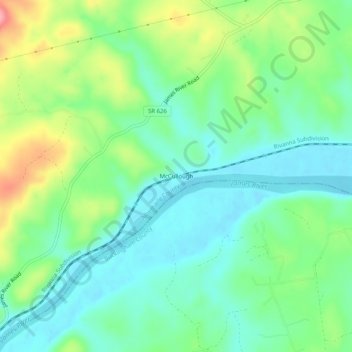
Name: McCullough topographic map, elevation, terrain.

Location: McCullough, Albemarle County, Virginia, United States (37.73709 -78.63529 37.77709 -78.59529)

Average elevation: 404 ft

Minimum elevation: 285 ft

Maximum elevation: 663 ft

Albemarle County trails, hiking, mountain biking, running and outdoor activities

Other topographic maps

Click on a map to view its topography, its elevation and its terrain.

Crozet

United States > Virginia > Albemarle County > Crozet

Average elevation: 682 ft

Free Union

United States > Virginia > Albemarle County > Free Union

Average elevation: 518 ft

Keswick

United States > Virginia > Albemarle County > Keswick

Average elevation: 417 ft

Rio

United States > Virginia > Albemarle County > Rio

Average elevation: 489 ft

Ivy

United States > Virginia > Albemarle County

Average elevation: 614 ft

Rio

United States > Virginia > Albemarle County > Rio

Average elevation: 489 ft

Lake

United States > Virginia > Albemarle County > Hollymead

Average elevation: 495 ft

Crozet

United States > Virginia > Albemarle County > Crozet

Average elevation: 682 ft

Scottsville

United States > Virginia > Albemarle County

Average elevation: 377 ft

Gear up for your next adventure:

🪶Survival Guide Book - Expert advice for emergency preparedness
📖Nature Tracking Books - Learn to track wildlife and terrain
🌡️Handheld Weather Meters - Measure wind, temp, and pressure for safe mountain travel
🥇GPS Hiking Watch - Multi‑sport GPS watch with navigation and trail tracking
🏫Relief Map Kits - Hands-on tools for teaching landforms and elevation

As an Amazon Associate, this site earns from qualifying purchases at no extra cost to you.