
Addicks Reservoir topographic map
Click on the map to display elevation.
Addicks Reservoir
Addicks Reservoir is formed by a rolled earthen dam 61,666 feet (18,796 m) long and above the streambed. A 12-foot-wide (3.7 m) gravel road extends along the top of the dam. The top of the dam has a maximum elevation of 121 feet (37 m) above the NAVD 1988 and is almost 50 feet high in points. The maximum storage capacity of the reservoir is 201,000 acre-feet (248,000,000 cubic metres; 248 gigalitres), The record high water level for the reservoir prior to Hurricane Harvey was 123,100 acre-feet (151,800,000 m3; 151.8 GL), set on April 24, 2016.
About this map
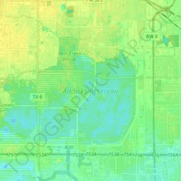
Name: Addicks Reservoir topographic map, elevation, terrain.
Average elevation: 102 ft
Minimum elevation: 75 ft
Maximum elevation: 131 ft
Harris County trails, hiking, mountain biking, running and outdoor activities
Other topographic maps
Click on a map to view its topography, its elevation and its terrain.
original boundary of City of Houston
United States > Texas > Harris County > Houston
Average elevation: 52 ft
Mount Houston
United States > Texas > Harris County > Houston > Mount Houston
Average elevation: 69 ft
Hunters Ridge
United States > Texas > Harris County > Houston > Hunters Ridge
Average elevation: 82 ft