
Make a donation
Gear up for your next adventure:
As an Amazon Associate, this site earns from qualifying purchases at no extra cost to you.
Leeds and Grenville topographic map
Click on the map to display elevation.
Make a donation
Gear up for your next adventure:
As an Amazon Associate, this site earns from qualifying purchases at no extra cost to you.
About this map
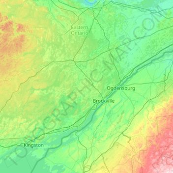
Name: Leeds and Grenville topographic map, elevation, terrain.
Average elevation: 479 ft
Minimum elevation: 164 ft
Maximum elevation: 2,310 ft
Make a donation
Gear up for your next adventure:
As an Amazon Associate, this site earns from qualifying purchases at no extra cost to you.
Other topographic maps
Click on a map to view its topography, its elevation and its terrain.
Lower Beverley Lake
Canada > Ontario > Leeds and Grenville Counties > Rideau Lakes > Delta
Average elevation: 371 ft
Make a donation
Gear up for your next adventure:
As an Amazon Associate, this site earns from qualifying purchases at no extra cost to you.
Leeds and the Thousand Islands
Canada > Ontario > Leeds and Grenville Counties
Average elevation: 335 ft