Geolocate

Yatta topographic map

Click on the map to display elevation.

About this map

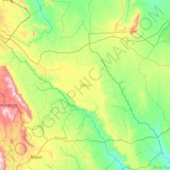
Name: Yatta topographic map, elevation, terrain.

Location: Yatta, Machakos County, East Kenya, 90120, Kenya (-1.49946 37.34390 -0.98859 37.81971)

Average elevation: 4,042 ft

Minimum elevation: 3,261 ft

Maximum elevation: 6,056 ft

Other topographic maps

Click on a map to view its topography, its elevation and its terrain.

Syokimau

Kenya > Machakos County > Mavoko

Average elevation: 5,308 ft

Athi River

Kenya > Machakos County > Mavoko

Average elevation: 4,987 ft

Machakos

Kenya > Machakos County

Average elevation: 5,466 ft

Gear up for your next adventure:

🪶Paracord Bracelet - Survival bracelet with built‑in tools
🧦Merino Wool Socks - Moisture-wicking, blister-preventing socks for long treks
🎒Trekking Poles - Sturdy poles for balance and stability on rough terrain
🎁Geography Themed Gifts - Unique gift ideas for map lovers and geography enthusiasts
🏥Hiking First Aid Kits - Comprehensive medical kits for remote trail injuries

As an Amazon Associate, this site earns from qualifying purchases at no extra cost to you.