Geolocate

Fishers topographic map

Click on the map to display elevation.

About this map

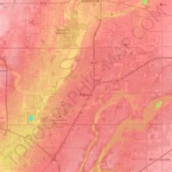
Name: Fishers topographic map, elevation, terrain.

Location: Fishers, Hamilton County, Indiana, United States (39.92696 -86.07655 40.00108 -85.86210)

Average elevation: 807 ft

Minimum elevation: 502 ft

Maximum elevation: 896 ft

Hamilton County trails, hiking, mountain biking, running and outdoor activities

Other topographic maps

Click on a map to view its topography, its elevation and its terrain.

Newark Village

United States > Indiana > Hamilton County > Carmel

Average elevation: 833 ft

West Park

United States > Indiana > Hamilton County > Carmel

Average elevation: 899 ft

Lake Windemere

United States > Indiana > Hamilton County > Carmel

Average elevation: 896 ft

Aroma

United States > Indiana > Hamilton County

Average elevation: 840 ft

Halifax Park

United States > Indiana > Hamilton County > Carmel

Average elevation: 899 ft

Lake Windemere

United States > Indiana > Hamilton County > Carmel

Average elevation: 896 ft

Carmel

United States > Indiana > Hamilton County > Carmel > Carmel

Average elevation: 833 ft

Gear up for your next adventure:

🏥Hiking First Aid Kits - Comprehensive medical kits for remote trail injuries
🚪Portable Camp Chair - Foldable chair for comfort at camp
🪑Portable Camp Table - Compact table for campsite meals
🪓Survival Multi‑Tool - Versatile tool for camp and trail tasks
🥄Camping Utensil Set - Lightweight utensils for outdoor meals

As an Amazon Associate, this site earns from qualifying purchases at no extra cost to you.