Geolocate

Moorcroft topographic map

Click on the map to display elevation.

About this map

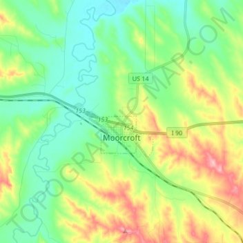
Name: Moorcroft topographic map, elevation, terrain.

Location: Moorcroft, Crook County, Wyoming, United States (44.25533 -104.97355 44.28389 -104.83845)

Average elevation: 4,268 ft

Minimum elevation: 4,114 ft

Maximum elevation: 4,570 ft

Crook County trails, hiking, mountain biking, running and outdoor activities

Other topographic maps

Click on a map to view its topography, its elevation and its terrain.

Devils Tower

United States > Wyoming > Crook County

Average elevation: 4,055 ft

Gear up for your next adventure:

🛡️Insect Repellent - Protection against bugs during outdoor activities
🥄Camping Utensil Set - Lightweight utensils for outdoor meals
🪶Camp Gear Gift Set - Perfect gift bundle for outdoor fans
🧴Hand Sanitizer - Keep hands clean while hiking
🔥Plasma Lighters - Windproof lighters that work in any weather condition

As an Amazon Associate, this site earns from qualifying purchases at no extra cost to you.