Geolocate

Devils Tower topographic map

Click on the map to display elevation.

About this map

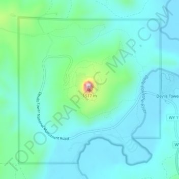
Name: Devils Tower topographic map, elevation, terrain.

Location: Devils Tower, Crook County, Wyoming, 82714, United States (44.59017 -104.71517 44.59027 -104.71507)

Average elevation: 4,055 ft

Minimum elevation: 3,839 ft

Maximum elevation: 5,075 ft

Crook County trails, hiking, mountain biking, running and outdoor activities

Other topographic maps

Click on a map to view its topography, its elevation and its terrain.

Moorcroft

United States > Wyoming > Crook County

Average elevation: 4,268 ft

Hulett

United States > Wyoming > Crook County > Hulett

Average elevation: 3,862 ft

Gear up for your next adventure:

📦Dry Bags Set - Waterproof storage for electronics and clothes
🛌Ultralight Sleeping Bags - Compact down bags for cold nights in the wilderness
🥇GPS Hiking Watch - Multi‑sport GPS watch with navigation and trail tracking
🎒Day Hiking Backpack - Lightweight backpack perfect for day trips and outdoor adventures
❄️Traction Cleats - Prevent slips on icy trails during winter hikes

As an Amazon Associate, this site earns from qualifying purchases at no extra cost to you.